इंडोर वेफाइंडिंग: व्यवसायों के लिए तकनीकों, अनुप्रयोगों और लाभों की एक व्यापक मार्गदर्शिका
This guide provides a comprehensive technical overview of indoor wayfinding for IT leaders and venue operators. It details the core technologies, deployment strategies, and business benefits, offering actionable guidance for implementing a system that enhances visitor experience and delivers measurable ROI.
🎧 Listen to this Guide
View Transcript

कार्यकारी सारांश
CTO, IT प्रबंधकों और वेन्यू ऑपरेशंस निदेशकों के लिए, एक प्रभावी इंडोर वेफाइंडिंग सिस्टम तैनात करना अब कोई विलासिता नहीं बल्कि एक रणनीतिक अनिवार्यता है। कॉर्पोरेट परिसरों, अस्पतालों, रिटेल केंद्रों और स्टेडियमों जैसे जटिल इंडोर वातावरणों में, निर्बाध नेविगेशन सीधे तौर पर बेहतर विज़िटर अनुभव, उन्नत परिचालन दक्षता और महत्वपूर्ण ROI में बदल जाता है। यह मार्गदर्शिका इंडोर वेफाइंडिंग समाधान की योजना बनाने, उसे लागू करने और बनाए रखने के लिए एक तकनीकी संदर्भ के रूप में कार्य करती है। हम प्राथमिक तकनीकों—WiFi, ब्लूटूथ लो एनर्जी (BLE), और अल्ट्रा-वाइडबैंड (UWB)—और सटीकता, लागत और जटिलता में उनके संबंधित ट्रेड-ऑफ़ का पता लगाएंगे। यह दस्तावेज़ प्रारंभिक साइट सर्वेक्षण और बुनियादी ढांचे की तैनाती से लेकर CRM और बिल्डिंग मैनेजमेंट सिस्टम (BMS) जैसे एंटरप्राइज़ सिस्टम के साथ एकीकरण तक, एक चरणबद्ध कार्यान्वयन ढांचे का विवरण देता है। महत्वपूर्ण रूप से, हम व्यावसायिक प्रभाव को मापेंगे, वास्तविक दुनिया के केस स्टडीज़ का हवाला देते हुए जो पुनः प्राप्त उत्पादकता और छूटी हुई नियुक्तियों में कमी से लाखों की लागत बचत को प्रदर्शित करते हैं। मौजूदा नेटवर्क बुनियादी ढांचे का लाभ उठाकर, जैसा कि Purple का प्लेटफ़ॉर्म करता है, संगठन डेटा-संचालित निर्णयों को चलाने वाले और अधिक स्मार्ट, अधिक उत्तरदायी वेन्यू अनुभव बनाने वाले शक्तिशाली लोकेशन एनालिटिक्स को अनलॉक करते हुए अग्रिम निवेश को कम कर सकते हैं। यह मार्गदर्शिका WPA3 जैसे सुरक्षा मानकों को पूरा करने वाले और GDPR जैसे डेटा गोपनीयता नियमों का अनुपालन करने वाले समाधान को तैयार करने के लिए आवश्यक वेंडर-न्यूट्रल सर्वोत्तम प्रथाओं और तकनीकी अंतर्दृष्टि प्रदान करती है。
तकनीकी डीप-डाइव
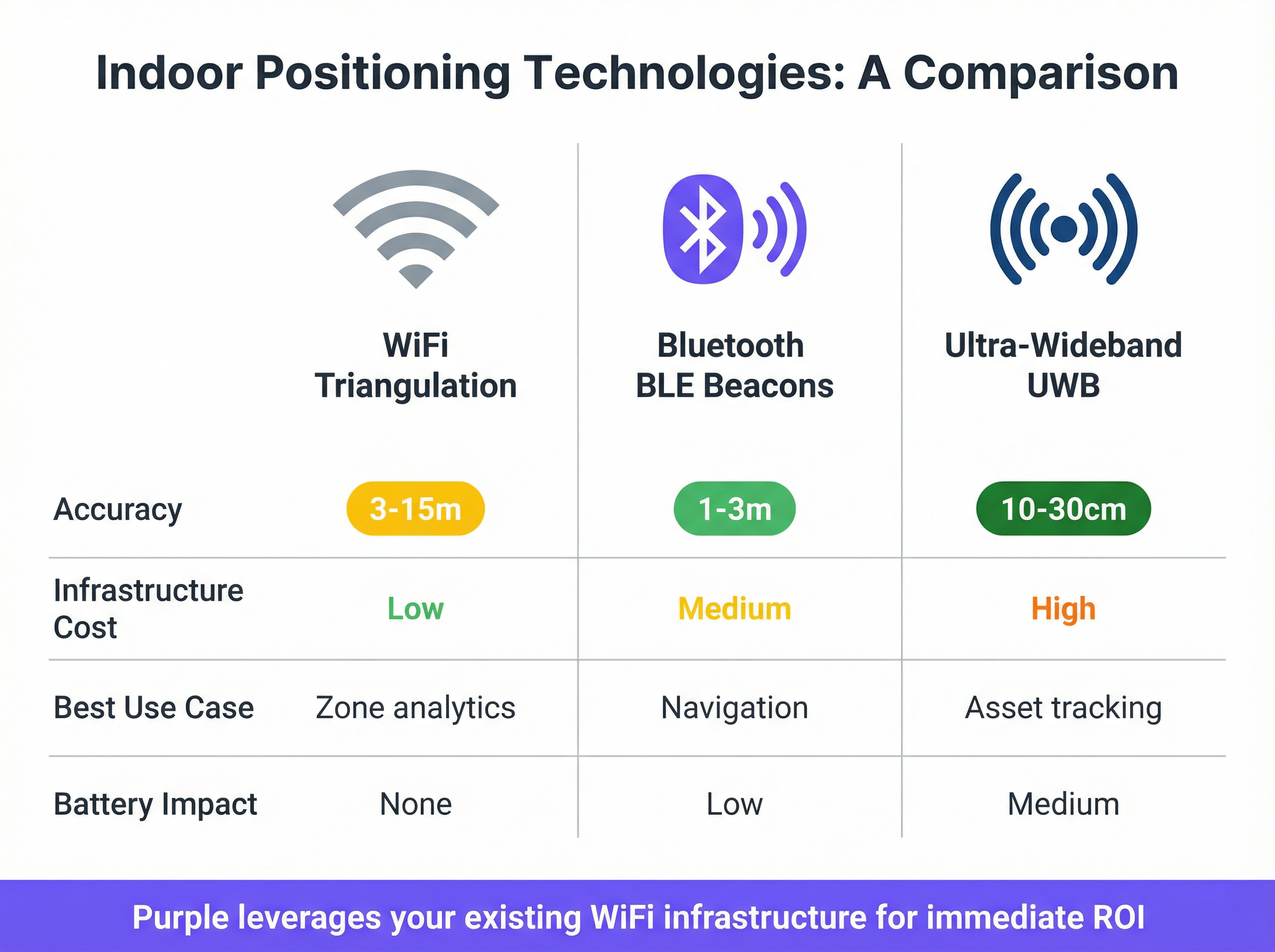
इंडोर पोज़िशनिंग सिस्टम (IPS) को शक्ति प्रदान करने वाली तकनीकों को समझना सही समाधान चुनने के लिए महत्वपूर्ण है। तकनीक का चुनाव सटीकता, स्केलेबिलिटी, लागत और रखरखाव ओवरहेड को निर्धारित करता है। एंटरप्राइज़ वातावरण में उपयोग की जाने वाली तीन प्राथमिक विधियाँ WiFi-आधारित पोज़िशनिंग, ब्लूटूथ लो एनर्जी (BLE) बीकन और अल्ट्रा-वाइडबैंड (UWB) हैं।
WiFi-आधारित पोज़िशनिंग
WiFi इंडोर वेफाइंडिंग के लिए सबसे सर्वव्यापी तकनीक है, मुख्य रूप से क्योंकि यह वेन्यू को अपने मौजूदा वायरलेस नेटवर्क बुनियादी ढांचे का लाभ उठाने की अनुमति देता है, जिससे प्रारंभिक तैनाती लागत काफी कम हो जाती है। पोज़िशनिंग आमतौर पर रिसीव्ड सिग्नल स्ट्रेंथ इंडिकेशन (RSSI) फ़िंगरप्रिंटिंग जैसी विधियों के माध्यम से प्राप्त की जाती है, जहाँ उपयोगकर्ता की स्थिति को त्रिकोणीय (triangulate) करने के लिए कई एक्सेस पॉइंट से सिग्नल की शक्ति को मापा जाता है। लागत प्रभावी होने के बावजूद, RSSI-आधारित सटीकता आम तौर पर 3-15 मीटर की सीमा में होती है, जो इसे सटीक, टर्न-बाय-टर्न दिशा-निर्देशों के बजाय ज़ोन-स्तरीय एनालिटिक्स, उपस्थिति का पता लगाने और बुनियादी नेविगेशन के लिए आदर्श बनाती है। IEEE 802.11mc के हिस्से, WiFi RTT (राउंड-ट्रिप टाइम) जैसे नए मानक, क्लाइंट डिवाइस और एक्सेस पॉइंट के बीच सिग्नल को यात्रा करने में लगने वाले समय को मापकर बहुत अधिक सटीकता (1-2 मीटर) प्रदान करते हैं। Purple का प्लेटफ़ॉर्म सिस्को (Cisco), जुनिपर (Juniper - Mist), और अरूबा (Aruba) जैसे वेंडरों के मौजूदा एंटरप्राइज़ WiFi के साथ एकीकृत होकर उत्कृष्ट प्रदर्शन करता है, ताकि पूर्ण हार्डवेयर ओवरहाल की आवश्यकता के बिना तत्काल लोकेशन एनालिटिक्स और वेफाइंडिंग क्षमताएं प्रदान की जा सकें।
ब्लूटूथ लो एनर्जी (BLE) बीकन
BLE बीकन छोटे, बैटरी से चलने वाले ट्रांसमीटर होते हैं जो एक विशिष्ट पहचानकर्ता (unique identifier) प्रसारित करते हैं। मोबाइल डिवाइस इन सिग्नलों का पता लगा सकते हैं और बीकन से अपनी निकटता निर्धारित करने के लिए उनका उपयोग कर सकते हैं। वेफाइंडिंग के लिए, पूरे वेन्यू में बीकन का एक ग्रिड तैनात किया जाता है। कई बीकन से सिग्नल की शक्ति को मापकर, एक एप्लिकेशन 1-3 मीटर की सटीकता के साथ उपयोगकर्ता की स्थिति की गणना कर सकता है। यह BLE को टर्न-बाय-टर्न नेविगेशन और रूम-स्तरीय सटीकता के लिए उपयुक्त बनाता है। हालाँकि, इस दृष्टिकोण के लिए संभावित रूप से हजारों बैटरी-संचालित उपकरणों की स्थापना और रखरखाव की आवश्यकता होती है, जो बड़े वेन्यू के लिए एक महत्वपूर्ण परिचालन बोझ पेश करता है। बैटरी जीवन, तैनाती घनत्व और पर्यावरणीय कारक सभी सिस्टम के प्रदर्शन को प्रभावित कर सकते हैं और इसके लिए निरंतर प्रबंधन की आवश्यकता होती है।
अल्ट्रा-वाइडबैंड (UWB)
UWB उच्चतम स्तर की सटीकता प्रदान करता है, जो 10-30 सेंटीमीटर के भीतर किसी स्थान को सटीक रूप से इंगित करने में सक्षम है। यह एक विस्तृत फ़्रीक्वेंसी स्पेक्ट्रम में रेडियो ऊर्जा के बहुत छोटे पल्स भेजकर काम करता है। एक टैग और कई रिसीवर (एंकर) के बीच इन सिग्नलों के टाइम-ऑफ़-फ़्लाइट को मापकर, सिस्टम एक सटीक 3D स्थिति की गणना कर सकता है। यह सटीकता UWB को औद्योगिक अनुप्रयोगों, उच्च-मूल्य वाली संपत्ति ट्रैकिंग और स्टाफ ड्यूरेस अलर्ट जैसे सुरक्षा-महत्वपूर्ण परिदृश्यों के लिए आदर्श बनाती है। हालाँकि, UWB के लिए एंकर और टैग के एक समर्पित बुनियादी ढांचे की आवश्यकता होती है, जिससे यह तैनात करने के लिए सबसे महंगा विकल्प बन जाता है। यद्यपि फ्लैगशिप स्मार्टफ़ोन द्वारा इसे तेजी से समर्थन दिया जा रहा है, इसका प्राथमिक एंटरप्राइज़ उपयोग सामान्य सार्वजनिक वेफाइंडिंग के बजाय विशेष, उच्च-सटीकता वाले अनुप्रयोगों में बना हुआ है।
| तकनीक | सटीकता | बुनियादी ढांचा लागत | सर्वोत्तम उपयोग का मामला | प्रमुख मानक |
|---|---|---|---|---|
| WiFi (RSSI) | 3-15 मीटर | कम (मौजूदा नेटवर्क का लाभ उठाता है) | ज़ोन एनालिटिक्स, उपस्थिति | IEEE 802.11ax (Wi-Fi 6) |
| WiFi (RTT/FTM) | 1-2 मीटर | कम (संगत हार्डवेयर की आवश्यकता है) | टर्न-बाय-टर्न नेविगेशन | IEEE 802.11mc |
| BLE बीकन | 1-3 मीटर | मध्यम | टर्न-बाय-टर्न नेविगेशन | ब्लूटूथ 5.1+ |
| अल्ट्रा-वाइडबैंड (UWB) | 10-30 सेमी | उच्च | उच्च-सटीकता एसेट ट्रैकिंग | IEEE 802.15.4 |
कार्यान्वयन मार्गदर्शिका
एक सफल इंडोर वेफाइंडिंग तैनाती एक संरचित, बहु-चरणीय दृष्टिकोण का पालन करती है। उचित योजना के बिना कार्यान्वयन में जल्दबाजी करना विफलता का एक सामान्य कारण है, जिससे खराब सटीकता, कम उपयोगकर्ता अपनाना और ROI प्राप्त करने में विफलता होती है। निम्नलिखित रोडमैप एंटरप्राइज़ तैनाती के लिए सर्वोत्तम-अभ्यास कार्यप्रणाली की रूपरेखा तैयार करता है।
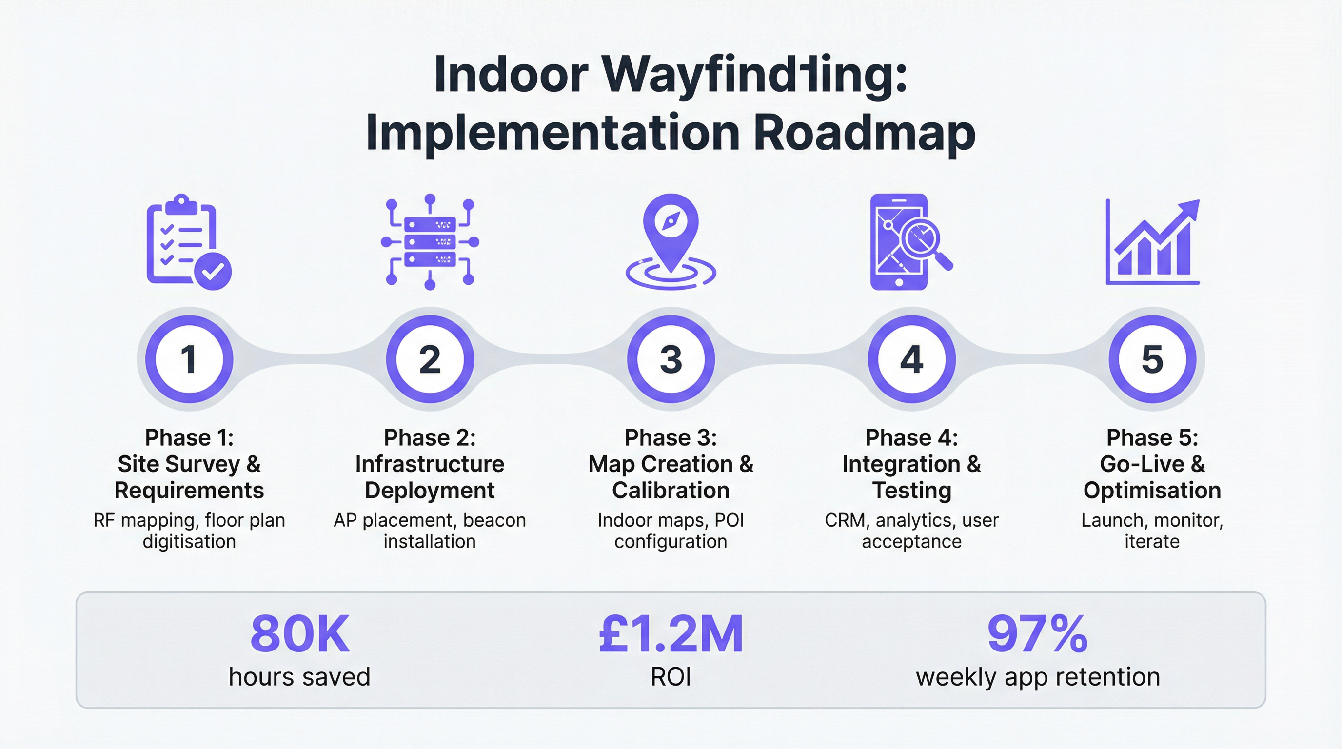
चरण 1: साइट सर्वेक्षण और आवश्यकताएँ एकत्र करना इस मूलभूत चरण में वेन्यू का गहन मूल्यांकन शामिल है। प्रमुख गतिविधियों में हस्तक्षेप और डेड ज़ोन के संभावित स्रोतों की पहचान करने के लिए RF (रेडियो फ़्रीक्वेंसी) सर्वेक्षण करना, सटीक डिजिटल फ़्लोर प्लान प्राप्त करना या बनाना, और विशिष्ट उपयोग के मामलों और व्यावसायिक उद्देश्यों को परिभाषित करना शामिल है। IT, ऑपरेशंस और मार्केटिंग टीमों के साथ हितधारक साक्षात्कार यह सुनिश्चित करने के लिए महत्वपूर्ण हैं कि सिस्टम को अस्पताल में रोगी के प्रवाह में सुधार से लेकर रिटेल सेटिंग में ड्वेल टाइम (dwell time) बढ़ाने तक विविध आवश्यकताओं को पूरा करने के लिए डिज़ाइन किया गया है।
चरण 2: बुनियादी ढांचे की तैनाती चुनी गई तकनीक और साइट सर्वेक्षण परिणामों के आधार पर, इस चरण में हार्डवेयर की भौतिक स्थापना शामिल है। WiFi-आधारित सिस्टम के लिए, इसमें पर्याप्त कवरेज सुनिश्चित करने के लिए मौजूदा एक्सेस पॉइंट के प्लेसमेंट को अनुकूलित करना या नए जोड़ना शामिल हो सकता है। BLE या UWB सिस्टम के लिए, बीकन या एंकर की रणनीतिक नियुक्ति और स्थापना की आवश्यकता होती है। सभी हार्डवेयर तैनाती को बिल्डिंग कोड का पालन करना चाहिए और दैनिक कार्यों में व्यवधान को कम करने के लिए योजनाबद्ध किया जाना चाहिए।
चरण 3: मानचित्र निर्माण और अंशांकन (Calibration) बुनियादी ढांचा स्थापित होने के साथ, डिजिटल मानचित्र बनाए और कैलिब्रेट किए जाते हैं। इसमें फ़्लोर प्लान को डिजिटल बनाना और उन्हें पोज़िशनिंग ग्रिड के साथ ओवरले करना शामिल है। पॉइंट्स ऑफ़ इंटरेस्ट (POI), जैसे मीटिंग रूम, रिटेल स्टोर, या अस्पताल के विभाग, मानचित्र पर परिभाषित और जियोलोकेट किए जाते हैं। पोज़िशनिंग मॉडल (उदा., WiFi या BLE फ़िंगरप्रिंट) बनाने के लिए पूरे वेन्यू में माप लेकर सिस्टम को कैलिब्रेट किया जाता है। यह कदम सिस्टम की सटीकता के लिए महत्वपूर्ण है।
चरण 4: एकीकरण और परीक्षण एंटरप्राइज़ वेफाइंडिंग सिस्टम की वास्तविक शक्ति एकीकरण के माध्यम से अनलॉक होती है। इस चरण में API के माध्यम से लोकेशन प्लेटफ़ॉर्म को अन्य व्यावसायिक प्रणालियों से जोड़ना शामिल है। उदाहरणों में रोगियों को नियुक्तियों के लिए मार्गदर्शन करने के लिए अस्पताल के इलेक्ट्रॉनिक स्वास्थ्य रिकॉर्ड (EHR) सिस्टम के साथ एकीकरण, मीटिंग रूम बुक करने के लिए कॉर्पोरेट कैलेंडर, या स्थान-आधारित ऑफ़र देने के लिए रिटेल CRM शामिल हैं। यह सुनिश्चित करने के लिए कठोर उपयोगकर्ता स्वीकृति परीक्षण (UAT) किया जाता है कि सिस्टम सटीक, विश्वसनीय है और एक सहज उपयोगकर्ता अनुभव प्रदान करता है।
चरण 5: गो-लाइव और अनुकूलन एक सफल परीक्षण चरण के बाद, सिस्टम उपयोगकर्ताओं के लिए लॉन्च किया जाता है। जागरूकता और अपनाने को बढ़ावा देने के लिए लॉन्च को एक संचार योजना द्वारा समर्थित किया जाना चाहिए। लॉन्च के बाद, काम खत्म नहीं होता है। अनुकूलन के अवसरों की पहचान करने के लिए सिस्टम द्वारा उत्पन्न लोकेशन एनालिटिक्स डेटा की निरंतर निगरानी की जानी चाहिए। हीटमैप भीड़भाड़ वाले क्षेत्रों को प्रकट कर सकते हैं जिन्हें संबोधित करने की आवश्यकता है, जबकि पाथिंग विश्लेषण वेन्यू लेआउट और प्रवाह को बेहतर बनाने के अवसर दिखा सकता है।
सर्वोत्तम प्रथाएँ
- उपयोगकर्ता गोपनीयता को प्राथमिकता दें: सुनिश्चित करें कि आपका समाधान GDPR अनुपालक है। जहां संभव हो डेटा को गुमनाम करें और उपयोगकर्ताओं को उनकी स्थान जानकारी पर स्पष्ट नियंत्रण प्रदान करें। Purple जैसे प्लेटफ़ॉर्म अपने मूल में गोपनीयता के साथ डिज़ाइन किए गए हैं।
- एक्सेसिबिलिटी के लिए डिज़ाइन करें: आपका वेफाइंडिंग समाधान समावेशी होना चाहिए। व्हीलचेयर-सुलभ मार्ग, दृष्टिबाधित लोगों के लिए वॉयस-ओवर कमांड और बहु-भाषा समर्थन जैसी सुविधाओं को शामिल करें।
- नेटवर्क को सुरक्षित करें: वेफाइंडिंग सिस्टम आपके नेटवर्क का विस्तार हैं। सुनिश्चित करें कि सभी संचार एन्क्रिप्टेड हैं और तैनाती नेटवर्क एक्सेस कंट्रोल के लिए WPA3 और IEEE 802.1X जैसे एंटरप्राइज़ सुरक्षा मानकों का पालन करती है।
- पायलट के साथ शुरुआत करें: पूर्ण पैमाने पर रोलआउट से पहले, अपने वेन्यू के एक सीमित क्षेत्र में एक पायलट प्रोजेक्ट आयोजित करें। यह आपको तकनीक को मान्य करने, उपयोगकर्ता प्रतिक्रिया एकत्र करने और एक नियंत्रित वातावरण में अपनी तैनाती रणनीति को परिष्कृत करने की अनुमति देता है।
- एकीकरण पर ध्यान दें: एक स्टैंडअलोन वेफाइंडिंग ऐप का सीमित मूल्य है। उच्चतम ROI वर्कफ़्लो को स्वचालित करने और संदर्भ-जागरूक अनुभव बनाने के लिए मुख्य व्यावसायिक प्रक्रियाओं और अनुप्रयोगों में स्थान डेटा को एकीकृत करने से आता है।
समस्या निवारण और जोखिम न्यूनीकरण
- सिग्नल हस्तक्षेप: निर्माण सामग्री (धातु, कंक्रीट) या अन्य वायरलेस उपकरणों से RF हस्तक्षेप पोज़िशनिंग सटीकता को कम कर सकता है। एक गहन साइट सर्वेक्षण इस जोखिम के लिए प्राथमिक न्यूनीकरण है।
- कैलिब्रेशन ड्रिफ्ट: समय के साथ, भौतिक वातावरण में परिवर्तन (उदा., बड़े फर्नीचर को स्थानांतरित करना, मौसमी भीड़) पोज़िशनिंग मॉडल को कम सटीक बना सकते हैं। प्रदर्शन को बनाए रखने के लिए आवधिक पुन: अंशांकन (recalibration) की योजना बनाएं।
- कम उपयोगकर्ता अपनाना: यदि ऐप सहज नहीं है या किसी वास्तविक समस्या का समाधान नहीं करता है, तो लोग इसका उपयोग नहीं करेंगे। डिज़ाइन प्रक्रिया में अंतिम उपयोगकर्ताओं को शामिल करें और लॉन्च के समय सिस्टम के लाभों का भारी प्रचार करें।
- डेटा अशुद्धि: गलत या पुरानी मानचित्र जानकारी एक आम समस्या है। वेन्यू में बदलाव के साथ POI और मानचित्र लेआउट को अपडेट करने के लिए एक स्पष्ट प्रक्रिया स्थापित करें।
ROI और व्यावसायिक प्रभाव
इंडोर वेफाइंडिंग के लिए व्यावसायिक मामला दक्षता, अनुभव और राजस्व में मापने योग्य सुधारों पर बनाया गया है। कॉर्पोरेट सेटिंग में, Pointr का डेटा दिखाता है कि कर्मचारी कमरों की खोज में लगने वाले समय को समाप्त करके प्रति मीटिंग औसतन 12 मिनट बचाते हैं, जो प्रति कर्मचारी सालाना लगभग 20 दिनों की पुनः प्राप्त उत्पादकता और एक औसत परिसर के लिए $1.46 मिलियन की लागत बचत में बदल जाता है। हेल्थकेयर में, क्रॉयडन यूनिवर्सिटी अस्पताल (Croydon University Hospital) में Purple की तैनाती के परिणामस्वरूप छूटी हुई नियुक्तियों को कम करके और पहले दिशा-निर्देश देने में खर्च किए गए 80,000 घंटे के स्टाफ समय की बचत करके कुल £1.2 मिलियन की बचत हुई। रिटेल में, वेफाइंडिंग ड्वेल टाइम (dwell time) बढ़ाता है, विशिष्ट ज़ोन में फुट ट्रैफ़िक में सुधार करता है, और स्थान-आधारित मार्केटिंग को सक्षम बनाता है जो सीधे बिक्री बढ़ा सकता है। कुंजी आपके विशिष्ट वेन्यू के लिए लक्ष्य KPI को परिभाषित करना और उस प्रभाव को मापने और रिपोर्ट करने के लिए लोकेशन एनालिटिक्स प्लेटफ़ॉर्म का लाभ उठाना है।
Key Terms & Definitions
Indoor Positioning System (IPS)
A system that continuously determines the real-time location of objects or people inside a building. Unlike GPS, which is ineffective indoors, an IPS uses technologies like WiFi, Bluetooth, or UWB.
IT teams deploy an IPS as the core engine for any indoor location-based service, including wayfinding, asset tracking, and location analytics.
Wayfinding
The process of orienting and navigating from point to point in a physical environment. Digital wayfinding provides this service through mobile apps or kiosks, offering turn-by-turn directions.
For venue operators, wayfinding is the primary user-facing application of an IPS, directly impacting visitor experience by reducing stress and improving efficiency.
WiFi RTT (Round-Trip Time)
A feature specified in the IEEE 802.11mc standard that enables an access point to calculate its distance from a client device with high accuracy (1-2 meters) by measuring the time it takes for a radio signal to travel between them.
Network architects should specify RTT-compatible hardware for new WiFi deployments to enable high-accuracy indoor positioning without needing a separate beacon infrastructure.
Bluetooth Beacon
A small, low-power radio transmitter that repeatedly broadcasts a unique identifier. Mobile devices can detect this signal to determine their proximity to the beacon.
In wayfinding deployments, beacons are installed throughout a venue to create a positioning grid. They represent a trade-off: higher accuracy than basic WiFi, but with the added cost and maintenance of battery-powered hardware.
Ultra-Wideband (UWB)
A short-range wireless communication protocol that uses a wide portion of the radio spectrum to achieve highly accurate, centimetre-level positioning. It measures the precise time-of-flight of radio signals.
CTOs should consider UWB for specialised, mission-critical use cases like tracking surgical equipment in a hospital or managing automated guided vehicles in a warehouse, where the high cost is justified by the need for extreme precision.
RSSI (Received Signal Strength Indicator)
A measurement of the power present in a received radio signal. In wayfinding, the RSSI from multiple access points or beacons is used to estimate a user's location via triangulation or fingerprinting.
While RSSI is a foundational metric for most positioning systems, IT teams must understand that it can be affected by obstacles, interference, and multi-path fading, which is why calibration is so important.
Geofencing
A virtual perimeter for a real-world geographic area. A geofencing system can trigger an action (like sending a push notification) when a device enters or leaves this defined area.
Venue operators use geofencing to create location-aware marketing campaigns, sending a promotional offer to a visitor's phone when they walk past a specific store, or to trigger operational alerts for staff.
GDPR (General Data Protection Regulation)
A regulation in EU law on data protection and privacy for all individuals within the European Union and the European Economic Area. It governs how personal data is collected, processed, and stored.
When deploying any location-based service, IT and compliance teams must ensure the platform is GDPR-compliant, providing users with transparency and control over their data. This is a non-negotiable requirement for enterprise deployments.
Case Studies
A 500-bed hospital needs to reduce late and missed appointments, which cost the trust over £1 million annually. Patients frequently report getting lost in the large, complex facility, causing stress and delays. Staff are interrupted constantly for directions, reducing time available for patient care. The hospital has an existing enterprise-grade WiFi network from a major vendor.
The recommended solution is to deploy a WiFi-based indoor wayfinding system, leveraging the hospital's existing network infrastructure to minimise costs. The implementation would follow a phased approach:
- Assessment: Digitize the hospital's floor plans and conduct an RF survey to confirm WiFi coverage is sufficient for positioning. Integrate with the hospital's Patient Administration System (PAS) to access appointment schedules.
- Map Creation: Create a detailed digital map of the hospital, including all departments, clinics, wards, and amenities as Points of Interest (POIs). Define accessible routes for wheelchair users.
- Application: Develop a mobile application (or integrate into the existing hospital app) that provides patients with turn-by-turn navigation from the hospital entrance directly to their appointment location. Send a link to the map in appointment reminder notifications.
- Analytics: Use the platform's analytics dashboard to monitor patient flow, identify bottlenecks, and measure the impact on appointment punctuality. Track staff time saved through reduced interruptions.
A large shopping centre with over 300 retail units wants to increase visitor dwell time and drive foot traffic to under-utilised zones. The marketing team wants to run targeted promotional campaigns but lacks the tools to reach shoppers in real-time within the venue.
Deploy a guest WiFi and indoor positioning solution. The system would serve a dual purpose: providing valuable guest internet access and enabling location-based services.
- Captive Portal: Implement a branded captive portal for WiFi login. This provides an opportunity to capture anonymised visitor data (with consent) and promote the wayfinding app.
- Wayfinding & Promotions: The mobile app provides a full store directory and turn-by-turn navigation. Using geofencing, the system can trigger push notifications with relevant offers when a shopper dwells near a particular store or enters a specific zone.
- Analytics for Tenants: The location analytics platform generates valuable insights for both the mall operator and its retail tenants. Heatmaps show visitor traffic patterns, dwell times, and popular paths. This data can be used to inform leasing decisions, optimise store layouts, and measure the effectiveness of marketing campaigns.
Scenario Analysis
Q1. You are the CTO of a multi-campus university. Students complain about finding lecture halls, and the estates department wants to understand classroom utilisation better. Your WiFi network is due for a refresh in the next 12 months. What technology would you propose for a wayfinding and space utilisation solution, and why?
💡 Hint:Consider the upcoming network refresh and the dual requirements of navigation and analytics.
Show Recommended Approach
The recommended approach is to specify IEEE 802.11mc (WiFi RTT) compatible access points for the upcoming network refresh. This strategy leverages a single infrastructure investment to solve both problems. WiFi RTT will provide the 1-2 meter accuracy needed for effective turn-by-turn navigation for students. Simultaneously, the location data from the WiFi network can be fed into an analytics platform like Purple's to generate detailed space utilisation reports for the estates department, showing which lecture halls are occupied and when. This avoids the cost and complexity of deploying and managing a separate BLE beacon network.
Q2. A major international airport is planning to deploy a wayfinding solution to guide passengers to their gates. They are also under pressure to increase retail revenue. The IT Director is concerned about the cost of a full beacon deployment across all terminals. How would you advise them?
💡 Hint:Think about how to generate revenue from the system to offset its cost.
Show Recommended Approach
Advise a hybrid approach that leverages the existing airport WiFi network for baseline coverage and supplements it with BLE beacons in key high-traffic retail areas. The business case should be built around ROI, not just cost. By integrating the wayfinding app with a location-based marketing engine, the airport can generate new revenue. When a passenger with the app dwells near a duty-free shop, the system can send a targeted voucher. This promotional revenue can be used to fund the infrastructure deployment. The analytics on passenger flow and dwell time are also highly valuable for optimising retail layouts and negotiating tenant leases.
Q3. You are an IT Manager at a large manufacturing plant. The operations director wants to track the location of high-value tools and automated guided vehicles (AGVs) on the factory floor to prevent loss and optimise workflows. Accuracy needs to be extremely high to avoid collisions and ensure safety. What is your primary recommendation?
💡 Hint:The key requirements are high precision and reliability in a challenging RF environment.
Show Recommended Approach
The only suitable technology for this use case is Ultra-Wideband (UWB). While WiFi and BLE are effective for people navigation, they cannot provide the centimetre-level accuracy and low latency required for tracking moving equipment in a dynamic industrial environment. The risk of collision with AGVs or misplacing a critical tool justifies the higher deployment cost of a dedicated UWB infrastructure (anchors and tags). The solution should be integrated with the plant's Manufacturing Execution System (MES) to provide real-time location data that can be used to automate workflows and trigger safety alerts.
Key Takeaways
- ✓Indoor wayfinding is a strategic tool for improving visitor experience and operational efficiency in large venues.
- ✓The primary technologies are WiFi, BLE beacons, and UWB, each with different trade-offs in accuracy, cost, and complexity.
- ✓Leveraging existing enterprise WiFi infrastructure offers the fastest path to ROI for many organisations.
- ✓A structured, phased implementation approach is critical for success, from site survey to post-launch optimisation.
- ✓The highest ROI is achieved by integrating location data with core business systems (e.g., CRM, EHR, BMS).
- ✓Data privacy and security (GDPR, WPA3) are non-negotiable requirements for any enterprise deployment.
- ✓Real-world deployments have demonstrated multi-million pound savings through increased productivity and efficiency.
