Si estás evaluando un indoor positioning system, probablemente te enfrentes a un problema común. Los huéspedes se pierden entre la recepción y su habitación. Los compradores usan tu WiFi, pero sigues sin poder ver cómo se mueven por el centro comercial. El personal clínico pierde tiempo buscando equipos. Tu red ya cubre el edificio, pero los datos de ubicación siguen guardados en un plan de proyecto independiente, desconectados de la identidad, la analítica y las operaciones.
Ahí es donde la mayoría de las conversaciones sobre IPS fallan. Los equipos pasan semanas comparando balizas, anclajes y métodos de radio, para luego darse cuenta de que lo difícil no es solo localizar un dispositivo en interiores. Es transformar esa señal de ubicación en algo que la empresa pueda usar de manera segura, constante y sin crear otra plataforma aislada que gestionar.
Un indoor positioning system funciona mejor cuando se trata como parte de la red general y del stack de identidad. La capa de radio es importante. La capa de integración es aún más importante.
¿Qué es un Indoor Positioning System?
La navegación en exteriores parece sencilla porque el GPS hace el trabajo pesado. Tu teléfono detecta los satélites, calcula dónde está y muestra un punto azul en un mapa. En interiores, ese modelo falla porque las paredes, techos, elevadores, cuartos de máquinas y materiales de construcción densos interfieren con esas débiles señales satelitales.
Un indoor positioning system cubre ese vacío. Te ofrece una forma de estimar dónde se encuentra una persona, un teléfono o un activo etiquetado dentro de un edificio donde el GPS no puede realizar el trabajo de manera confiable.

Más que un mapa con un punto azul
Muchos compradores imaginan inicialmente el IPS como un sistema de navegación por satélite para interiores. Eso es parte de ello, pero es solo la capa visible.
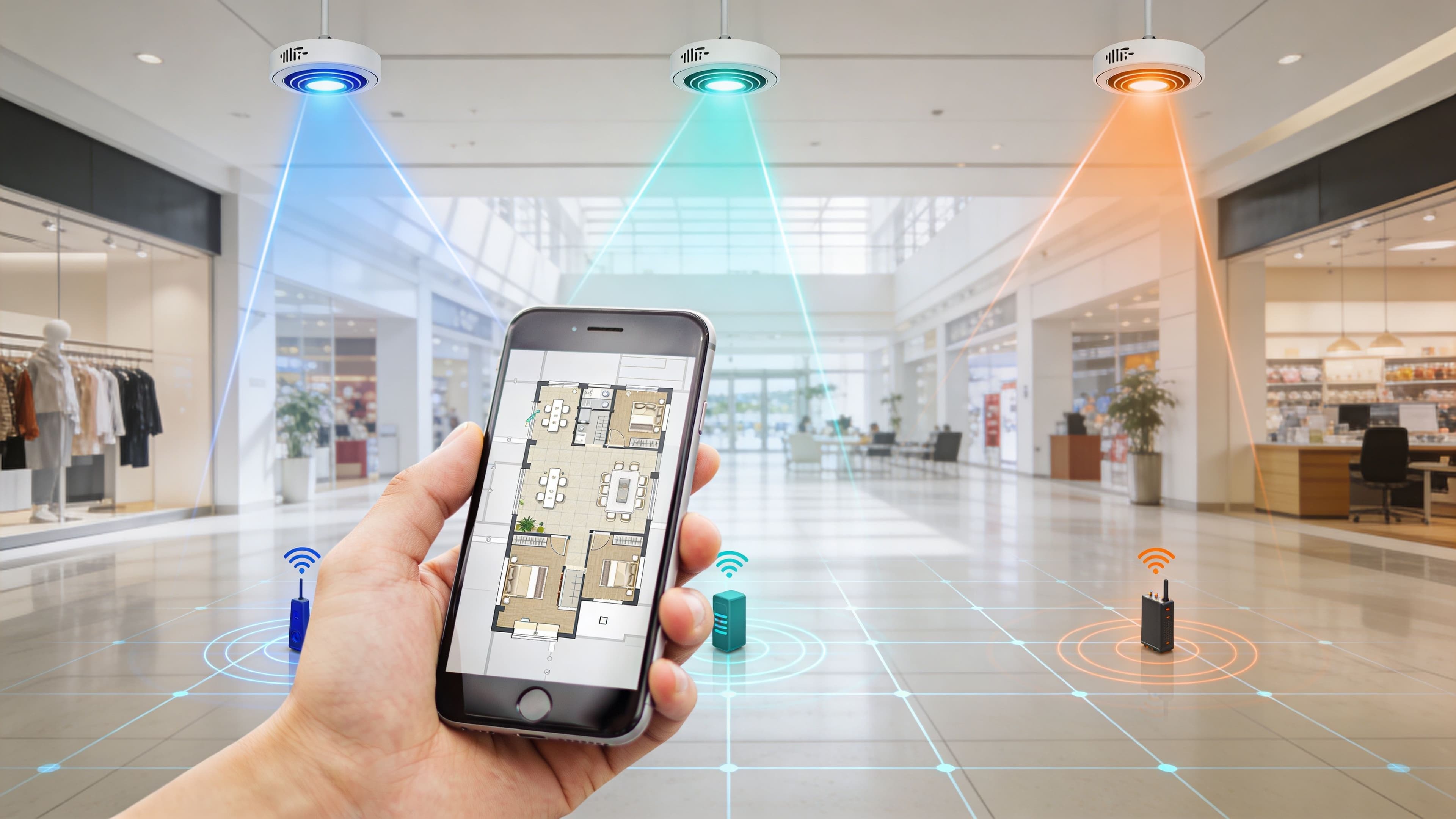
En la práctica, un indoor positioning system es una combinación de:
- Fuentes de señal como puntos de acceso WiFi, balizas BLE o anclajes UWB
- Lógica de software que interpreta esas señales y estima la posición
- Mapas y planos de planta que convierten las coordenadas en ubicaciones útiles
- Aplicaciones e integraciones que utilizan los datos de ubicación para navegación, analítica, seguridad o automatización
Piensa en ello como el equivalente en interiores de un sistema de seguimiento logístico. Los radiotransmisores te dicen dónde se encuentra probablemente algo. El software traduce eso en "cerca del vestíbulo del elevador", "afuera de la sala de juntas" o "en el nivel tres cerca de cardiología". Los sistemas empresariales deciden qué hacer con esa información.
El problema que realmente resuelve
La mayoría de los recintos no necesitan datos de ubicación por el simple hecho de tenerlos. Los necesitan para eliminar la fricción.
Un hotel quiere que los huéspedes encuentren el ascensor correcto, el bar, el spa o la sala de conferencias sin tener que preguntar al personal. Un centro comercial quiere entender los patrones de movimiento, no solo la afluencia en las entradas. Un hospital quiere que los médicos localicen el equipo y encuentren el camino hacia los departamentos con menos demoras.
El posicionamiento en interiores solo se vuelve valioso cuando la estimación de la ubicación se conecta a un flujo de trabajo real. Navegación, dotación de personal, soporte, marketing u operaciones.
Por qué el IPS es un sistema, no un solo producto
Esta es la parte que muchos subestiman en sus primeras implementaciones. No se puede comprar "una caja de IPS" y esperar que resuelva la orientación en interiores en una propiedad compleja.
Cada implementación depende de un equilibrio de factores:
| Elemento de IPS | Qué hace | Por qué es importante |
|---|---|---|
| Capa de señal | Detecta dispositivos o etiquetas en interiores | Determina la cobertura y la precisión bruta |
| Motor de ubicación | Convierte las mediciones de radio en posiciones | Afecta la confiabilidad en edificios reales |
| Capa de mapas | Alinea las posiciones con pisos y espacios | Hace que el resultado sea utilizable para las personas |
| Capa de integración | Conecta los datos con aplicaciones y flujos de trabajo | Crea valor comercial |
Si el mapa es deficiente, la navegación falla. Si la integración es débil, el análisis de datos se queda aislado. Si falta la capa de identidad, se puede ver el movimiento pero no conectarlo de manera responsable con los recorridos de los huéspedes o los eventos de servicio.
Comparación de tecnologías principales de IPS
Un grupo hotelero que planifica la orientación en interiores en veinte propiedades rara vez comienza desde cero. La pregunta clave no es qué tecnología de radio parece más avanzada, sino cuál se adapta a la red que ya opera, la precisión que requiere su caso de uso y la plataforma de identidad a la que desea conectarla.

Si compra basándose únicamente en la precisión, muchos proyectos de IPS se convertirán en costosos pilotos. Si compra en función de la capacidad de integración, los mismos datos de ubicación pueden alimentar aplicaciones para huéspedes, flujos de trabajo de servicio, análisis de recintos e informes vinculados a la identidad en plataformas como Purple.
Posicionamiento WiFi
WiFi suele ser la primera opción práctica porque la capa de acceso ya existe. En lugar de implementar una red de sensores independiente, el sistema estima la ubicación a partir de las mediciones de señal en toda su red inalámbrica.
Al principio de esta guía, señalamos que el posicionamiento WiFi suele situarse en el rango de unos pocos metros en lugar de una precisión milimétrica. En la práctica, eso suele ser suficiente para el guiado basado en zonas, el análisis de trayectorias, los mapas de calor y activadores como "el invitado ha llegado a la planta de conferencias" o "el visitante está cerca de la recepción."
WiFi también se adapta a las operaciones empresariales mejor de lo que muchos equipos esperan. Su equipo de red ya gestiona la infraestructura de AP. El cableado, la alimentación, el control de cambios y el monitoreo son familiares. Eso reduce la fricción de la implementación, especialmente en portafolios de múltiples sitios.
Dónde funciona bien WiFi
- Entornos WLAN empresariales existentes
- Guiado para invitados y visitantes
- Análisis a nivel de zona y análisis de permanencia
- Implementaciones donde la estandarización es importante en muchos sitios
Dónde tiene dificultades WiFi
- Localización de activos dentro de sub-habitaciones
- Flujos de trabajo clínicos o industriales que dependen de coordenadas exactas
- Edificios con densidad de AP inconsistente o comportamiento de RF difícil
El equilibrio es claro. WiFi suele ganar en economía de cobertura y adaptabilidad operativa. Pierde cuando el caso de negocio depende de saber en qué lado de una habitación se encuentra un elemento.
Balizas BLE
BLE se sitúa en un término medio. Es más barato de implementar que los sistemas de alta precisión y, por lo general, ofrece un mejor control de proximidad que WiFi por sí solo, especialmente para experiencias móviles.
Eso hace que BLE sea común en entornos de cara al cliente. Un recinto puede colocar balizas cerca de elevadores, salas de reuniones, tiendas o servicios, y usarlas para activar contenido de la app, mejorar el guiado paso a paso o medir la presencia en zonas definidas. El inconveniente es la sobrecarga operativa. Las infraestructuras de balizas parecen ligeras en la etapa de adquisición, pero luego crean ciclos de reemplazo de baterías, auditorías de ubicación y trabajo de calibración para el equipo que las hereda.
El comportamiento de los dispositivos móviles también importa más de lo que los compradores suelen asumir. Las reglas de escaneo difieren según el teléfono y el sistema operativo. La detección en segundo plano puede ser inconsistente. Si su estrategia de IPS depende de que los invitados instalen una app y otorguen los permisos correctos, planifique para una participación menor de la que sugiere el diagrama de arquitectura.
El verdadero equilibrio de BLE
- Bajo costo de hardware por punto
- Mejor lógica de proximidad que el WiFi básico
- Carga continua de mantenimiento y baterías
- Mayor variabilidad según la configuración del teléfono y los permisos de la app
BLE es una buena opción cuando la proximidad es el producto. Es una opción más débil cuando la empresa busca operaciones de bajo mantenimiento en cientos o miles de puntos finales.
UWB
UWB es la opción de precisión. Al principio del artículo, mencionamos cifras de precisión de hasta unos 30 cm. Ese nivel de rendimiento cambia lo que el sistema puede hacer.
En hospitales, sitios industriales y entornos de logística, UWB respalda los flujos de trabajo donde decir "en esta área" no es suficiente. Los equipos necesitan saber qué área de camas tiene un dispositivo etiquetado, qué carro salió de un área controlada o qué artículo está más cerca de un técnico. Es por eso que UWB suele aparecer junto al asset tracking software en lugar de plataformas de navegación para invitados.
La contrapartida es la infraestructura. UWB necesita anclajes dedicados, un diseño cuidadoso del sitio y un modelo de implementación que los edificios más antiguos no siempre reciben bien. Para un hotel de lujo o un espacio de uso mixto, eso suele significar un caso de renovación más difícil y un camino más largo para recuperar la inversión.
Comparación de tecnología IPS
| Tecnología | Precisión típica | Perfil de costo típico | Requisito de infraestructura | Mejor opción |
|---|---|---|---|---|
| WiFi | Nivel de habitación o zona en muchas implementaciones | Menor si la WLAN ya está instalada | APs existentes, trabajo de levantamiento, motor de ubicación | Búsqueda de rutas, mapas de calor, análisis de movimiento |
| BLE | Mejor control de proximidad que el WiFi solo, depende de la densidad de beacons y la calibración | Moderado | Colocación de beacons, gestión de baterías, mapeo | Navegación guiada por aplicación, activadores de zona, engagement local |
| UWB | Alta precisión, a menudo adecuado para el rastreo a nivel de artículo | Mayor | Anclajes dedicados, etiquetas, diseño especializado | Rastreo de activos críticos, flujos de trabajo industriales y clínicos |
Una prueba de compra útil es simple. Pregunte qué sistema de registro debe recibir el evento de ubicación.
Si la respuesta es su WiFi de invitados, CRM, lealtad o pila de identidad, WiFi y BLE suelen merecer la primera consideración porque se conectan de manera más natural con los recorridos digitales existentes. Si la respuesta es la telemetría operativa para equipos etiquetados, UWB a menudo justifica el costo adicional. Las implementaciones de IPS más sólidas no son las que tienen las especificaciones de radio más impresionantes. Son las que se adaptan al entorno de red, identidad e informes que ya tiene, y luego producen datos de ubicación que la empresa puede usar.
Casos de uso clave de IPS para empresas
A las 6:45 p.m., un huésped se registra en un hotel grande después de un vuelo demorado, se dirige al grupo de ascensores equivocado, pierde la reservación del restaurante y pide indicaciones al personal dos veces en diez minutos. En el mismo edificio, un equipo de eventos intenta redirigir a los delegados para evitar una fila afuera de un salón de baile, mientras que operaciones quiere saber por qué el spa se mantiene tranquilo en los fines de semana de mayor afluencia. Un sistema de posicionamiento en interiores puede ayudar con los tres problemas, pero solo si alimenta los sistemas que su equipo ya utiliza, no solo un mapa en una pantalla.

Wayfinding para huéspedes y visitantes
El wayfinding suele ser el primer caso de uso que los ejecutivos pueden imaginar, porque el problema es evidente. Los huéspedes, pacientes, visitantes y delegados pierden tiempo cuando los edificios son grandes, tienen varios niveles o están mal distribuidos. El personal también pierde tiempo, porque cada solicitud de indicaciones interrumpe a los equipos de recepción, conserjería, seguridad o personal clínico.
Un IPS bien diseñado convierte un mapa estático del sitio en una guía en tiempo real basada en la ubicación exacta del usuario. En un hotel, esto podría significar guiar a alguien desde la recepción hasta una habitación, un bar, una sala de reuniones o el área de estacionamiento. En un hospital, puede reducir las llegadas tardías y las citas perdidas al llevar a las personas al departamento correcto al primer intento.
El caso de negocio mejora cuando el wayfinding se vincula con los datos de identidad y de sesión. Si un huésped se ha autenticado en la WiFi o a través de una app, el recorrido puede iniciar desde el contexto de su reserva en lugar de un mapa genérico. Ahí es donde las plataformas conectadas a su red y capa de identidad, incluidos los entornos creados en torno a sistemas como Purple, comienzan a ganar relevancia. El evento de ubicación se convierte en parte del recorrido del cliente, no en una función de conveniencia aislada.
Flujo de personas y analítica de espacios
Este caso de uso es importante porque los planos de distribución rara vez reflejan el comportamiento real de las personas.
El IPS muestra cómo se mueven las personas a través de vestíbulos, pasillos, unidades comerciales, explanadas y espacios para eventos. Esto proporciona a los equipos operativos y comerciales información accionable. Pueden probar si la señalización funciona, si una fila es causada por el personal o la distribución, si los huéspedes evitan un lugar porque la ruta no es clara, o si una zona de alto valor recibe tráfico de paso pero no tiempo de permanencia.
Para el operador de un centro comercial, esto puede respaldar los informes de los inquilinos y las decisiones de arrendamiento. Para un grupo hotelero, puede mostrar si los huéspedes de conferencias pasan alguna vez por el bar, si la saturación del desayuno comienza en la entrada o en el punto de servicio, y si ciertos servicios permanecen ocultos a pesar de un marketing sólido. El resultado útil no es el mapa de calor por sí solo. Es una decisión sobre personal, señalización, distribución o promoción.
En la práctica, los proyectos más sólidos conectan los datos de movimiento con audiencias conocidas. Los datos de flujo anónimos son útiles para la planificación del espacio. Los datos de sesión identificados o consentidos es donde el valor comercial suele aumentar, porque la empresa puede comparar los patrones de ubicación con el gasto, el estado de lealtad, la exposición a campañas o el uso de servicios.
Seguimiento de activos en entornos operativos
El seguimiento de activos es a menudo donde el IPS justifica su presupuesto de manera más rápida.
Los hospitales, almacenes, campus y grandes recintos pierden horas cada semana buscando equipos móviles. Camas, sillas de ruedas, bombas, escáneres, carros de limpieza y herramientas de servicio se mueven constantemente. Sin una visibilidad confiable, los equipos crean soluciones alternativas manuales, como llamar a otros departamentos, revisar armarios o mantener un exceso de stock a la mano por si acaso.
La precisión es importante en este caso, pero el flujo de trabajo es aún más importante. Un punto de ubicación en una pantalla no ahorra mucho tiempo a menos que se vincule con los procesos de despacho, mantenimiento, limpieza o inventario. Los equipos que buscan visibilidad de almacenes o equipos móviles a menudo combinan el IPS con herramientas diseñadas específicamente, como el software de seguimiento de activos , para que los eventos de ubicación alimenten las tareas operativas en lugar de quedarse en un panel de control que nadie abre durante un turno ocupado.
Suelo aconsejar a los equipos que se hagan una pregunta contundente: ¿quién actúa ante la alerta? Si nadie es responsable del siguiente paso, el seguimiento sigue siendo interesante en lugar de útil.
Experiencias y alertas activadas por proximidad
La ubicación también puede activar acciones en tiempo real. Eso puede significar enviar un aviso de servicio cuando un huésped ingresa a un área de ocio, alertar a seguridad cuando alguien entra en una zona restringida o dirigir una tarea del personal al miembro del equipo más cercano disponible.
Un error común en muchos proyectos piloto es perder la disciplina. La demostración técnica parece impresionante, pero demasiados mensajes se convierten rápidamente en ruido. Un huésped no quiere recibir tres notificaciones de camino al desayuno. Una enfermera no necesita otra alerta que duplique un flujo de trabajo existente. Un buen diseño de proximidad utiliza la ubicación como un elemento de entrada junto con la identidad, el consentimiento, la hora del día, el estado de la reserva y las reglas de negocio.
Por eso también la integración importa más que el activador en sí. Si el IPS puede ver que un dispositivo está cerca del spa pero su CRM no puede distinguir a un huésped primerizo de un miembro de fidelidad, el mensaje será genérico. Si el IPS se conecta a sesiones autenticadas y perfiles de clientes, la acción puede ser más relevante y más fácil de medir.
El patrón detrás de las implementaciones más sólidas
Los casos de uso de IPS más sólidos suelen compartir tres rasgos de diseño:
- Un actor definido: huésped, comprador, médico, camillero, ingeniero
- Una acción definida: encontrar, enrutar, alertar, analizar, despachar
- Un propietario de sistema definido: operaciones, propiedades, marketing, prestación de servicios
Agregue un requisito más. El evento de ubicación necesita un sistema de destino que pueda hacer algo con él.
Ese es el cambio de un proyecto de hardware a un sistema de negocio. Una vez que los datos de IPS alimentan su red, identidad, CRM, flujos de trabajo de servicio y pila de informes, comienza a producir un valor operativo y comercial medible.
Diseño de su arquitectura e integración de IPS
Un huésped camina desde la recepción hasta el vestíbulo de los elevadores. La red puede ver el dispositivo. El IPS puede estimar la ubicación. La pregunta que importa es qué sucede después.
Si ese evento no se puede vincular a una sesión autenticada, a un estado de consentimiento, a un perfil de cliente o a un flujo de trabajo operativo, la empresa obtiene un punto en un mapa y poco más. En la práctica, la arquitectura decide si el IPS se convierte en una herramienta de analítica, en un activador de servicios o en otro flujo aislado del que ningún equipo se hace responsable.

La arquitectura principal en la práctica
Un diseño empresarial utilizable suele tener cuatro capas de trabajo. Cada una conlleva un modo de falla diferente.
| Capa | Rol en el stack | Pregunta de diseño común |
|---|---|---|
| Radio y detección | Recopila datos de señales de WiFi, BLE, UWB o sensores de dispositivos | ¿Qué cobertura y precisión necesitamos? |
| Motor de posicionamiento | Calcula la ubicación estimada | ¿Qué tan estable es la ubicación bajo las condiciones reales del lugar? |
| Identidad y políticas | Conecta a los usuarios o dispositivos con sesiones autenticadas y permisos | ¿Quién es este usuario o endpoint y qué tiene permitido hacer? |
| Sistemas de negocio | Utiliza eventos de ubicación en CRM, analítica, marketing u operaciones | ¿Qué acción debería activar esta ubicación? |
La cobertura de radio es solo el primer paso. Normalmente veo más problemas en las capas superiores. Un IPS técnicamente sólido sigue teniendo un rendimiento inferior si las ID de los dispositivos no se pueden asociar con usuarios reales, si los mapas de las plantas no coinciden con el edificio o si los eventos de ubicación no tienen un destino útil.
La identidad es el punto de control. Sin ella, los datos de ubicación son principalmente análisis de movimiento anónimos. Eso todavía puede respaldar la planificación y los informes de ocupación, pero no sirve de mucho para los recorridos personalizados de los huéspedes, los flujos de trabajo del personal o las acciones basadas en políticas. Una vez que la ubicación se vincula a sesiones autenticadas y reglas de consentimiento, el mismo evento se puede filtrar, enriquecer y dirigir al sistema adecuado.
Por qué importan las entradas híbridas
Los edificios interfieren con el posicionamiento. Las señales se reflejan en equipos de planta, elevadores, acristalamientos, pozos de servicio y multitudes densas. La precisión también varía según la hora del día a medida que cambia la ocupación.
Es por eso que los diseños de IPS maduros a menudo combinan múltiples entradas en lugar de depender de una sola fuente de radio. Una revisión de PMC sobre métodos de posicionamiento en interiores describe sistemas avanzados que utilizan fusión de sensores, incluyendo IMU, SLAM de cámara y WiFi SLAM, para mejorar la precisión de la ubicación. En términos prácticos, eso se traduce en menos saltos en el mapa y un historial de movimiento más estable.
La contrapartida es la complejidad. Los sistemas híbridos pueden mejorar la precisión, pero también aumentan el trabajo de calibración, la dependencia de los dispositivos, el consumo de energía y el esfuerzo de integración. Para un grupo hotelero, eso solo tiene sentido si los sistemas posteriores pueden utilizar la precisión añadida. Si la acción comercial es la atribución de marketing a nivel de zona, el rendimiento submétrico puede no tener ningún beneficio comercial. Si la acción es despachar personal o ubicar equipos en áreas clínicamente sensibles, el caso es diferente.
Uso inteligente de la infraestructura de red existente
Para muchos hoteles, propiedades de retail, bloques de alojamiento estudiantil y centros de salud, el punto de partida sensato es la red que ya está instalada. Los puntos de acceso WiFi existentes, los flujos de autenticación y los registros de sesión a menudo proporcionan el núcleo operativo para IPS, incluso cuando otra tecnología maneja la capa final de precisión.
Eso cambia la conversación sobre el diseño. La red inalámbrica no solo transporta tráfico. También es parte de la pila de detección e identidad.
Purple a menudo se ubica en esa capa de identidad. Maneja la autenticación de invitados y del personal, vincula las sesiones con usuarios conocidos o grupos de políticas, y transfiere datos de origen (first-party data) a los sistemas de análisis, CRM y marketing. En un lugar con gran afluencia de invitados, esto es importante porque la ubicación sin identidad es difícil de accionar, y la identidad sin contexto de red pierde el momento preciso en que se debe activar un servicio o mensaje.
Un buen diseño comienza con el sistema receptor, no con el mapa.
Si ninguna plataforma está lista para consumir el evento, actuar sobre él y medir el resultado, el proyecto de IPS tendrá dificultades para avanzar más allá de una prueba piloto.
Puntos de integración que merecen atención
El trabajo de integración suele decidir si el IPS se convierte en parte de las operaciones diarias o sigue siendo un panel de control que solo el equipo del proyecto revisa.
- Mapas y jerarquía de pisos: Los planos de planta, las etiquetas de las habitaciones, las entradas y las rutas de navegación necesitan un control de versiones. Una sola remodelación o cambio de numeración de habitaciones puede dañar la confianza rápidamente.
- Resolución de identidad: Los dispositivos, usuarios, invitados y cuentas del personal necesitan un modelo de emparejamiento confiable. Los dispositivos compartidos y las reglas de privacidad complican esto más de lo que muchos equipos esperan.
- Conectores de CRM y marketing: Estos son importantes cuando los eventos de ubicación se utilizan para la segmentación, la supresión de campañas, el análisis de tiempo de permanencia o los informes de recorrido del usuario.
- Plataformas de servicios y operaciones: Las alertas, el despacho, la limpieza, el mantenimiento y los flujos de trabajo de activos necesitan acciones del sistema, no monitoreo manual.
- Controles de acceso y seguridad: Los entornos multisitio y multitenant necesitan separación de políticas, permisos basados en roles y audibilidad.
- Retención de datos y consentimiento: El análisis de invitados, el seguimiento del personal y la telemetría operativa no siguen las mismas reglas. La política de retención debe diseñarse desde el principio, no parchearse después.
Las arquitecturas más sólidas se mantienen disciplinadas. Comience con un modelo de identidad limpio, un modelo espacial actualizado y una o dos integraciones que resuelvan un problema comercial real. Así es como el IPS pasa de hardware y coordenadas a inteligencia de negocio que los equipos de TI, operaciones y comerciales pueden usar.
Implementación práctica y mejores prácticas
Un grupo hotelero aprueba el posicionamiento en interiores para la orientación de los huéspedes, los flujos de trabajo del personal y el análisis del espacio. Seis meses después, el hardware está instalado, el mapa se ve bien en una demostración y operaciones aún no lo utiliza. En la práctica, las implementaciones fallan en la calibración, las políticas y la integración con los sistemas en los que sus equipos ya confían.
Comience con la decisión operativa, luego establezca el objetivo de precisión
La precisión es un requisito de negocio antes de ser uno técnico.
Si el objetivo es activar un mensaje de bienvenida cerca de la recepción o comprender el flujo de personas entre el bar y las salas de conferencias, la ubicación a nivel de zona puede ser suficiente. Si el objetivo es encontrar una silla de ruedas, rastrear un carrito de limpieza o distinguir entre salas de tratamiento adyacentes, la tolerancia es mucho más estricta. Esos son proyectos diferentes, con diferentes costos, métodos de prueba y modelos de soporte.
Esa compensación se nota rápidamente en propiedades más antiguas. Según la discusión de Blueiot sobre GPS versus posicionamiento en interiores , el 68% de los sitios de hospitalidad en el Reino Unido enfrentan costos de modernización superiores a £50,000 para puertas de enlace UWB debido a las regulaciones de edificios protegidos, mientras que los sistemas híbridos WiFi-RSSI que utilizan los puntos de acceso existentes pueden lograr una precisión de 1 a 2 metros y reducir los costos en un 75% en comparación con UWB. Para los equipos inmobiliarios que trabajan en hoteles históricos o lugares de uso mixto, esto puede decidir si el proyecto se financia.
La pregunta práctica es simple. ¿Qué acción tomará alguien a partir del evento de ubicación y qué tan equivocado puede estar el sistema antes de que esa acción pierda valor?
Valide el edificio que tiene, no el que está en el plano
Los planos de planta rara vez coinciden con las condiciones reales por mucho tiempo. Los puntos de acceso se mueven. Los muebles cambian. Aparecen mamparas para eventos. Un pasillo de servicio que parecía irrelevante en el papel resulta ser el lugar donde los activos etiquetados desaparecen durante la mayor parte del día.
Los estudios de cobertura (site surveys) deben probar el edificio bajo una carga realista. Eso significa comprobar el comportamiento de la señal durante las horas de actividad, no solo en un lugar vacío.
Concéntrese en cuatro áreas:
- Interferencia y atenuación de RF: estructuras metálicas, columnas de instalaciones, plantas de servicio, espejos, paredes gruesas y estanterías densas
- Ambigüedad vertical: huecos de escaleras, atrios, entrepisos y pisos de niveles divididos que confunden la detección de plantas
- Movimiento humano y operativo: picos de visitantes, rondas de limpieza, carros, carretillas y estructuras temporales para eventos
- La realidad de la red: ubicación real de los puntos de acceso, configuración de canales, niveles de potencia y zonas muertas
He visto fallar diseños técnicamente sólidos porque el estudio asumía condiciones estáticas en un edificio que cambia todos los días. Un IPS se parece menos a instalar un sensor y más a ajustar la cobertura de una red WiFi que la gente juzgará por el resultado, no por los gráficos de señal.
Incorpore la calibración y el mantenimiento de mapas en el modelo operativo
El sistema perderá precisión si nadie se hace responsable de él.
Un vestíbulo remodelado, una sala de reuniones renombrada o una actualización de puntos de acceso pueden mermar la confianza más rápido de lo que sugiere una cifra de precisión general. Los usuarios no informan que el modelo de coordenadas se desvió 1.5 metros. Informan que las indicaciones son incorrectas, que las alertas se activan en el lugar equivocado o que un panel de control ya no coincide con la realidad.
Las buenas implementaciones asignan responsabilidades para:
- Actualizaciones de planos de planta: etiquetas de salas, accesos, rutas bloqueadas y áreas públicas versus áreas exclusivas para el personal
- Revisiones de calibración: pruebas después de remodelaciones, cambios de puntos de acceso o modificaciones en la distribución del espacio
- Política de dispositivos: qué dispositivos son aptos para la localización, cómo se gestionan los dispositivos compartidos y cómo se retiran las etiquetas inactivas
- Gestión de excepciones: qué deben hacer los equipos de operaciones cuando la precisión de la localización cae por debajo del umbral para un flujo de trabajo
Las plataformas integradas con datos de identidad y red demuestran su valor. Si su IPS está conectado al WiFi de invitados, a los controles de acceso del personal y a los registros de identidad en una plataforma como Purple, los eventos de localización se vuelven más confiables y fáciles de gestionar. Sin ese vínculo, los equipos pasan demasiado tiempo conciliando dispositivos, usuarios y lugares de forma manual.
Trate la privacidad y la seguridad como parte del diseño
Los datos de localización se vuelven sensibles rápidamente porque están estrechamente vinculados a la identidad, el comportamiento y el historial de acceso. El análisis de visitantes, el seguimiento del personal y el monitoreo de activos no deben seguir el mismo conjunto de reglas.
Un plan de implementación viable contempla:
- Consentimiento y aviso: qué aceptan los usuarios, qué se recopila y qué servicios dependen de la localización
- Gestión de la identidad: dónde se seudonimizan, tokenizan o mantienen los datos separados de la información de identificación personal
- Ventanas de retención: diferentes reglas para telemetría operativa, análisis de la trayectoria del invitado y registros del personal
- Acceso basado en roles: permisos granulares para operaciones, marketing, seguridad y contratistas externos
- Revocación y auditoría: eliminación rápida de acceso cuando cambian los roles, además de registros que muestran quién vio qué
Los equipos a menudo descubren demasiado tarde que un sistema técnicamente preciso aún puede fallar en la revisión legal o la gobernanza interna. Es más barato establecer límites de política al principio que reconstruir los flujos de datos después del lanzamiento.
Pilote un flujo de trabajo que importe
Un piloto sólido es acotado y medible. Debe demostrar que los datos de ubicación son lo suficientemente confiables para una decisión operativa real, no solo que los puntos se mueven en una pantalla.
Para un hotel, eso podría significar reducir las interrupciones de los huéspedes en recepción mejorando la orientación hacia los espacios de reunión. Para un hospital, podría significar reducir el tiempo que el personal pasa localizando equipos móviles. Para un espacio de retail, podría ser medir la acumulación de filas y redistribuir al personal más rápido.
Mantenga el alcance estrecho. Un edificio, un piso, un grupo de usuarios, un resultado. Luego documente qué afectó el rendimiento: colocación de etiquetas, densidad de AP, esfuerzo de calibración, coincidencia de identidad y diseño del flujo de trabajo. Ese es el material que necesita para una implementación repetible en todo el inmueble.
Medición del ROI de su inversión en IPS
El posicionamiento en interiores no se justifica por su elegancia técnica. Se justifica cuando un espacio puede conectar los datos de ubicación con los ingresos, la eficiencia o la mejora del servicio.
Haga coincidir las métricas con el caso de uso
El KPI debe reflejar el resultado operativo que le interesa.
Para implementaciones orientadas al cliente, las medidas útiles a menudo incluyen:
- Comportamiento de permanencia: ¿La gente pasa más tiempo en las zonas prioritarias?
- Finalización de la trayectoria: ¿Los huéspedes o visitantes llegan a sus destinos con menos fricción?
- Respuesta a campañas: ¿Los avisos basados en la ubicación se correlacionan con las visitas o el engagement?
- Rendimiento del espacio: ¿Algunas áreas se utilizan en exceso, se ignoran o están mal señalizadas?
Para las implementaciones operativas, el enfoque cambia:
| Caso de uso | Señal de ROI útil | Qué le indica |
|---|---|---|
| Orientación para huéspedes | Menos interrupciones de soporte, llegadas más fluidas | Si la navegación está reduciendo la dependencia del personal |
| Visibilidad de activos | Recuperación más rápida y menos búsquedas manuales | Si los equipos están recuperando tiempo productivo |
| Análisis de espacio | Mejores decisiones de diseño y personal | Si los datos de movimiento mejoran las operaciones |
| Interacción contextual | Experiencias en el sitio más relevantes | Si la ubicación aporta valor más allá de los mensajes genéricos |
Use la ubicación como evidencia, no solo como resultado
Un error común es reportar el rendimiento del IPS solo a través de estadísticas técnicas como la calidad de la señal o la precisión del mapa. Eso le importa al equipo del proyecto, pero los líderes de finanzas y operaciones quieren pruebas de cambios en los resultados.
Eso significa vincular los eventos de ubicación con los sistemas de negocio. Si un invitado se conectó a WiFi, fue a un servicio del recinto y luego completó una reserva o compra, esa es una historia más sólida que decir que el sistema mapeó su ruta con éxito. Si una enfermera encontró un equipo más rápido porque el flujo de trabajo mostró su ubicación en la aplicación correcta, eso es más sólido que mostrar un panel lleno de puntos en movimiento.
Construya el caso de negocio de manera incremental
Los casos de negocio más sólidos suelen acumular varios logros moderados en lugar de depender de una sola promesa dramática.
Podría demostrar que el sistema ayuda a los equipos a:
- reducir la fricción en la orientación y navegación
- mejorar la utilidad de los datos de visitantes de primera mano
- optimizar la distribución y la señalización
- respaldar mejores decisiones de dotación de personal
- aumentar la confianza en la atribución de servicios y marketing
Cuando la ubicación, la identidad y la analítica trabajan juntas, el IPS deja de ser un elemento de costo para la infraestructura y se convierte en una fuente de evidencia operativa.
Preguntas frecuentes sobre el posicionamiento en interiores
¿Un sistema de posicionamiento en interiores siempre requiere una aplicación?
No. Algunas experiencias funcionan a través de datos del lado de la red, interfaces web o servicios vinculados a la identidad. Las implementaciones basadas en aplicaciones aún pueden tener sentido para una navegación más completa o recorridos de usuario repetidos, pero no son el único modelo.
¿Cómo maneja el IPS múltiples pisos?
Depende del método de posicionamiento, la calidad del mapeo y la calibración. Los edificios de múltiples pisos necesitan una separación cuidadosa de los pisos en el mapa y pruebas alrededor de escaleras, elevadores, atrios y espacios abiertos donde las señales pueden filtrarse entre niveles.
¿Qué suele generar la mayor sobrecarga de mantenimiento?
No es el panel de control. El trabajo continuo suele residir en el reemplazo de baterías de los beacons, las actualizaciones de mapas, la reconfiguración del recinto, el desvío de la calibración y el mantenimiento de la integración cuando cambian otros sistemas.
¿Puede el IPS respetar la privacidad del usuario?
Sí, pero solo si la privacidad se diseña desde el principio. El consentimiento, la anonimización, el acceso basado en roles y las políticas de retención deben ser explícitos. Si está conectando la ubicación con la identidad, la gobernanza debe ser tan madura como el diseño técnico.
¿El sistema más preciso es siempre la mejor opción?
No. La mejor opción es la que se adapta al flujo de trabajo, las limitaciones del edificio, el modelo de integración y el presupuesto. Muchos equipos compran de más en precisión y no invierten lo suficiente en los sistemas que harían que los datos fueran útiles.
Si está buscando cómo el posicionamiento en interiores se integra con el WiFi para invitados, la autenticación segura y la analítica de datos propios, vale la pena evaluar a Purple como parte de una arquitectura más amplia. Puede ayudar a conectar los datos de identidad, acceso e interacción para que los servicios de ubicación impulsen resultados operativos y comerciales reales, en lugar de estar aislados en una infraestructura independiente.