WiFi वेफ़ाइंडिंग के यांत्रिकी: ट्राइलैटरेशन और RSSI की व्याख्या
यह आधिकारिक मार्गदर्शिका WiFi वेफ़ाइंडिंग के तकनीकी यांत्रिकी का विवरण देती है, यह समझाते हुए कि ट्राइलैटरेशन और RSSI माप डिवाइस के स्थान का निर्धारण कैसे करते हैं। यह उद्यम स्थलों में स्थान सेवाएँ तैनात करने वाले IT लीडर्स के लिए कार्रवाई योग्य परिनियोजन रणनीतियाँ, अंशांकन पद्धतियाँ और वास्तुशिल्प सर्वोत्तम अभ्यास प्रदान करता है।
इस गाइड को सुनें
पॉडकास्ट ट्रांसक्रिप्ट देखें

कार्यकारी सारांश
उद्यम स्थल संचालकों के लिए, प्रभावी इनडोर स्थान सेवाएँ तैनात करने के लिए केवल एक्सेस पॉइंट से किसी स्थान को कवर करना पर्याप्त नहीं है। WiFi वेफ़ाइंडिंग के मूलभूत यांत्रिकी—ट्राइलैटरेशन और रिसीव्ड सिग्नल स्ट्रेंथ इंडिकेटर (RSSI) माप—किसी भी सफल परिनियोजन के लिए वास्तुशिल्प आवश्यकताओं को निर्धारित करते हैं। यह मार्गदर्शिका इस बात के तकनीकी सिद्धांतों में गहराई से उतरती है कि आपकी मौजूदा वायरलेस अवसंरचना डिवाइस की स्थिति कैसे निर्धारित करती है, सटीकता को प्रभावित करने वाले महत्वपूर्ण पर्यावरणीय चर, और विश्वसनीय स्थान इंटेलिजेंस प्रदान करने के लिए आवश्यक परिनियोजन मानक।
इन यांत्रिकी को समझना IT प्रबंधकों और नेटवर्क आर्किटेक्ट्स के लिए आवश्यक है, जिन्हें टर्न-बाय-टर्न नेविगेशन, एसेट ट्रैकिंग या फ़ुटफ़ॉल एनालिटिक्स प्रदान करने का काम सौंपा गया है। हम सिग्नल शक्ति और दूरी के बीच लॉगरिदमिक संबंध, कठोर अंशांकन की आवश्यकता, और आपके RF वातावरण से कार्रवाई योग्य व्यावसायिक मूल्य निकालने के लिए Purple जैसे हार्डवेयर-अज्ञेयवादी एनालिटिक्स प्लेटफ़ॉर्म के एकीकरण का पता लगाते हैं।
हमारे साथी पॉडकास्ट ब्रीफिंग को सुनें:
तकनीकी गहन-विश्लेषण
RSSI और ट्राइलैटरेशन के मूल सिद्धांत
अपने मूल में, WiFi वेफ़ाइंडिंग एक क्लाइंट डिवाइस के भौतिक स्थान को निर्धारित करने के लिए मौजूदा वायरलेस अवसंरचना पर निर्भर करता है। इसके लिए प्राथमिक तंत्र ट्राइलैटरेशन है, जिसे अक्सर, और गलत तरीके से, ट्रायंगुलेशन के रूप में संदर्भित किया जाता है। जबकि ट्रायंगुलेशन कोणों के आधार पर स्थिति की गणना करता है, ट्राइलैटरेशन ज्ञात संदर्भ बिंदुओं से दूरियों को मापकर स्थिति निर्धारित करता है।
एक WiFi संदर्भ में, ये संदर्भ बिंदु आपके एक्सेस पॉइंट (APs) हैं। दूरी का अनुमान रिसीव्ड सिग्नल स्ट्रेंथ इंडिकेटर (RSSI) से प्राप्त होता है। RSSI एक प्राप्त रेडियो सिग्नल में मौजूद शक्ति का माप है, जिसे मिलीवाट (dBm) के सापेक्ष डेसिबल में व्यक्त किया जाता है।
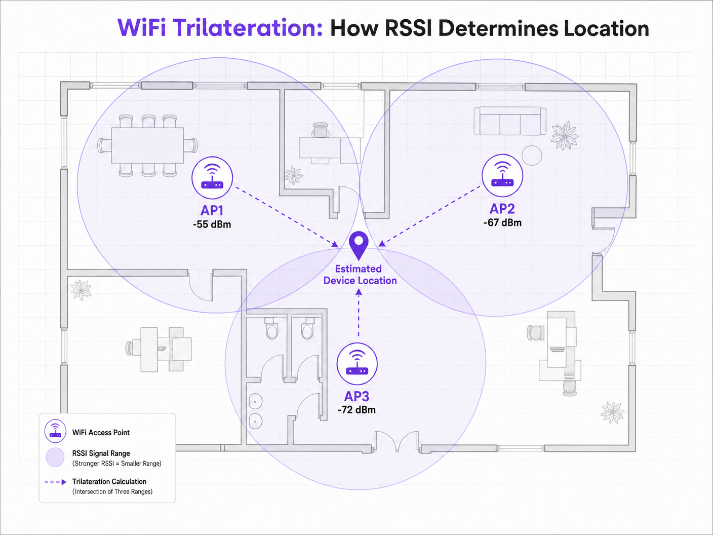
जब एक क्लाइंट डिवाइस—जैसे कि प्रोब रिक्वेस्ट प्रसारित करने वाला स्मार्टफोन—एक AP द्वारा पता लगाया जाता है, तो AP RSSI रिकॉर्ड करता है। क्योंकि रेडियो फ़्रीक्वेंसी (RF) सिग्नल अंतरिक्ष में यात्रा करते समय क्षीण (शक्ति खो देते हैं) होते हैं, RSSI मान दूरी के लिए एक प्रॉक्सी के रूप में कार्य करता है। यदि तीन या अधिक AP एक ही डिवाइस का पता लगाते हैं और उसका RSSI रिकॉर्ड करते हैं, तो पोजिशनिंग इंजन प्रत्येक AP से अनुमानित दूरी की गणना कर सकता है, जिससे संभावना के आभासी वृत्त बनते हैं। इन वृत्तों का प्रतिच्छेदन अनुमानित डिवाइस स्थान का प्रतिनिधित्व करता है।
पाथ-लॉस मॉडल
RSSI और दूरी के बीच संबंध रैखिक नहीं है; यह एक लॉगरिदमिक पाथ-लॉस मॉडल का अनुसरण करता है। पोजिशनिंग इंजन द्वारा उपयोग किया जाने वाला मानक सूत्र है:
RSSI = -10 * n * log10(d) + A
जहाँ:
- d एक्सेस पॉइंट से दूरी है।
- n पाथ-लॉस एक्सपोनेंट है, जो यह दर्शाता है कि विशिष्ट वातावरण में सिग्नल कितनी तेज़ी से खराब होता है। मुक्त-अंतरिक्ष निर्वात में, n ठीक 2.0 होता है। घने इनडोर वातावरण में, n 3.0 से 4.5 तक हो सकता है।
- A AP से ठीक 1 मीटर की दूरी पर मापा गया संदर्भ RSSI है।
यह सूत्र इस बात पर प्रकाश डालता है कि पर्यावरणीय अंशांकन क्यों महत्वपूर्ण है। कंक्रीट की दीवारों वाले Hospitality वातावरण में एक परिनियोजन में एक खुले Retail फ़्लोर की तुलना में काफी भिन्न पाथ-लॉस एक्सपोनेंट होगा। विविध वातावरणों में एक मानक n मान मानना खराब वेफ़ाइंडिंग सटीकता का प्रमुख कारण है।
पोजिशनिंग के लिए 2.4 GHz बनाम 5 GHz
जबकि 2.4 GHz बैंड भौतिक बाधाओं के माध्यम से बेहतर पैठ प्रदान करता है, यह विशेषता वास्तव में सटीक पोजिशनिंग के लिए हानिकारक है। बड़े प्रसार पदचिह्न का अर्थ है बड़े दूरी अनुमान वृत्त, जिसके परिणामस्वरूप प्रतिच्छेदन का एक व्यापक क्षेत्र और कम स्थितिगत रिज़ॉल्यूशन होता है।
5 GHz बैंड तेज़ी से क्षीण होता है, जिससे सख्त सिग्नल सीमाएँ और अधिक दानेदार दूरी अनुमान प्राप्त होते हैं। इष्टतम वेफ़ाइंडिंग सटीकता के लिए, पोजिशनिंग इंजनों को 5 GHz RSSI डेटा को प्राथमिकता देनी चाहिए। यह सिद्धांत नए मानकों पर भी लागू होता है; जबकि Wi-Fi 6 समग्र नेटवर्क दक्षता में सुधार करता है, RSSI पोजिशनिंग के मूलभूत यांत्रिकी समान रहते हैं, हालांकि Wi-Fi 6E में 6 GHz बैंड की शुरुआत से और भी अधिक चैनल घनत्व और संभावित रिज़ॉल्यूशन लाभ मिलते हैं। इस पर अधिक जानकारी के लिए, हमारी मार्गदर्शिका देखें: Wi-Fi 6 vs Wi-Fi 5: Does it Solve Channel Interference? ।
कार्यान्वयन मार्गदर्शिका
एक्सेस पॉइंट घनत्व और प्लेसमेंट
वेफ़ाइंडिंग परिनियोजन में सबसे आम विफलता मोड अपर्याप्त AP घनत्व है। केवल कनेक्टिविटी के लिए डिज़ाइन किया गया एक नेटवर्क (उदाहरण के लिए, Guest WiFi एक्सेस प्रदान करना) अक्सर विश्वसनीय ट्राइलैटरेशन के लिए आवश्यक घनत्व की कमी रखता है।
विश्वसनीय पोजिशनिंग के लिए, एक क्लाइंट डिवाइस को कम से कम तीन APs द्वारा एक साथ -75 dBm या बेहतर के RSSI पर "सुना" जाना चाहिए।
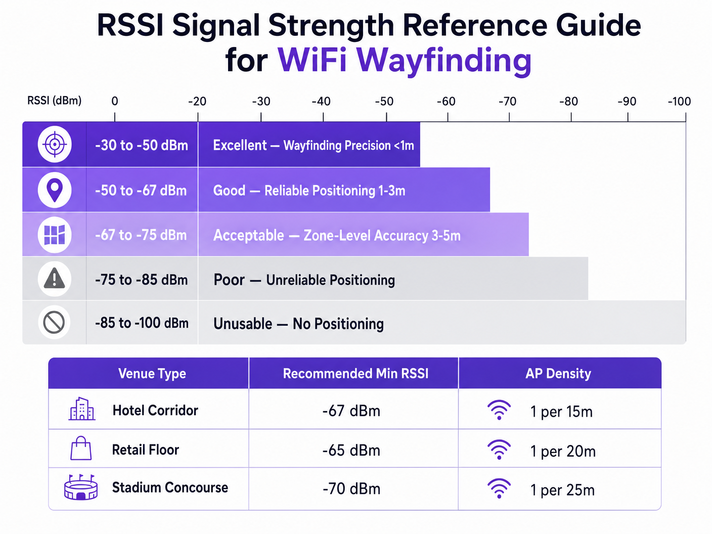
3 से 5 मीटर की लक्ष्य सटीकता प्राप्त करने के लिए, एक सामान्य नियम यह है कि पर्यावरण के आधार पर प्रति 15 से 20 वर्ग मीटर में एक AP तैनात किया जाए। इसके अलावा, APs को लक्ष्य क्षेत्र की परिधि पर रखा जाना चाहिए, न कि केवल एक गलियारे के केंद्र में, यह सुनिश्चित करने के लिए कि सिग्नल वृत्तों का प्रतिच्छेदन एक सीधी रेखा के बजाय एक निश्चित बिंदु बनाता है।
अंशांकन पद्धतियाँ
सटीक दूरीस्थिति अनुमान के लिए पोजिशनिंग इंजन को विशिष्ट RF वातावरण के अनुसार कैलिब्रेट करना आवश्यक है। इसके दो प्राथमिक दृष्टिकोण हैं:
- RF Fingerprinting: इसमें एक सर्वेक्षण उपकरण के साथ भौतिक रूप से स्थान पर चलना, ज्ञात निर्देशांक पर RSSI मान रिकॉर्ड करना और एक व्यापक लुकअप तालिका बनाना शामिल है। पोजिशनिंग इंजन फिर इस डेटाबेस के विरुद्ध वास्तविक समय के RSSI रीडिंग का मिलान करता है। यह उच्चतम सटीकता प्रदान करता है लेकिन इसमें बहुत अधिक श्रम लगता है और यदि भौतिक वातावरण बदलता है (जैसे, मौसमी खुदरा प्रदर्शन) तो इसे दोहराना होगा।
- Model-Based Positioning: यह दृष्टिकोण सिस्टम में परिभाषित पर्यावरणीय मापदंडों (दीवार के प्रकार, छत की ऊँचाई) के साथ पाथ-लॉस फ़ॉर्मूला का उपयोग करता है। इसे तैनात करना और बनाए रखना तेज़ है, और हालांकि यह फ़िंगरप्रिंटिंग की तुलना में थोड़ा कम सटीक है, यह आमतौर पर ज़ोन-स्तर के एनालिटिक्स और व्यापक वेफ़ाइंडिंग के लिए पर्याप्त है।
सर्वोत्तम अभ्यास
मल्टीपाथ इंटरफेरेंस को कम करना
अत्यधिक परावर्तक सतहों वाले वातावरण में—जैसे कांच के स्टोरफ्रंट, धातु के फिक्स्चर, या स्टेडियम की सीटें—RF सिग्नल उछलते हैं, जो कई रास्तों से रिसीवर तक पहुँचते हैं। यह मल्टीपाथ इंटरफेरेंस RSSI रीडिंग को विकृत करता है, क्योंकि रिसीवर सीधी और परावर्तित सिग्नल का कुल माप करता है, न कि स्वच्छ लाइन-ऑफ-साइट दूरी का।
मल्टीपाथ को कम करने के लिए रणनीतिक AP प्लेसमेंट (अत्यधिक परावर्तक कोनों से बचना), कठोर कैलिब्रेशन, और पोजिशनिंग इंजन के भीतर बुद्धिमान फ़िल्टरिंग एल्गोरिदम का संयोजन आवश्यक है जो असामान्य RSSI स्पाइक्स को छोड़ सकते हैं।
गोपनीयता और अनुपालन
MAC पतों के माध्यम से स्थान डेटा एकत्र करते समय (यहां तक कि निष्क्रिय रूप से जांच अनुरोधों के माध्यम से भी), IT टीमों को GDPR जैसे क्षेत्रीय गोपनीयता ढाँचों का अनुपालन सुनिश्चित करना चाहिए।
आधुनिक मोबाइल ऑपरेटिंग सिस्टम द्वारा MAC एड्रेस रैंडमाइजेशन का कार्यान्वयन प्रमाणीकरण के बिना व्यक्तिगत उपकरणों की दीर्घकालिक ट्रैकिंग को रोकता है। हालांकि, यह कुल फुटफॉल एनालिटिक्स में बाधा नहीं डालता है। व्यक्तिगत टर्न-बाय-टर्न वेफ़ाइंडिंग या व्यक्तिगत जुड़ाव प्रदान करने के लिए, स्थानों को स्पष्ट सहमति प्राप्त करनी होगी।
यहीं पर एक captive portal को एकीकृत करना आवश्यक हो जाता है। उपयोगकर्ताओं को प्रमाणित करने की आवश्यकता करके—शायद How a wi fi assistant Enables Passwordless Access in 2026 जैसे समाधान का लाभ उठाकर—स्थान कानूनी रूप से एक डिवाइस को एक व्यक्ति से जोड़ सकते हैं और ऑप्ट-इन स्थान सेवाएँ प्रदान कर सकते हैं। Purple का प्लेटफ़ॉर्म कनेक्ट लाइसेंस के तहत एक मुफ्त पहचान प्रदाता के रूप में कार्य करता है, जो इस अनुपालन आवश्यकता को सुव्यवस्थित करता है जबकि समृद्ध WiFi Analytics प्रदान करता है।
समस्या निवारण और जोखिम न्यूनीकरण
जब वेफ़ाइंडिंग की सटीकता कम हो जाती है, तो IT टीमों को निम्नलिखित कारकों का व्यवस्थित रूप से मूल्यांकन करना चाहिए:
- पर्यावरणीय विचलन: क्या स्थान में भौतिक परिवर्तन (नई दीवारें, सघन इन्वेंट्री) हुए हैं जो मूल कैलिब्रेशन को अमान्य करते हैं?
- AP पावर स्तर: क्या रेडियो रिसोर्स मैनेजमेंट (RRM) एल्गोरिदम गतिशील रूप से ट्रांसमिट पावर को समायोजित कर रहे हैं? पोजिशनिंग इंजन स्थिर संदर्भ बिंदुओं पर निर्भर करते हैं; आक्रामक गतिशील पावर समायोजन दूरी की गणना को विकृत कर देगा।
- क्लाइंट डिवाइस भिन्नता: विभिन्न स्मार्टफोन निर्माता अलग-अलग एंटीना डिज़ाइन का उपयोग करते हैं, जिसका अर्थ है कि एक ही स्थान पर एक Samsung और एक iPhone अलग-अलग RSSI मान रिपोर्ट कर सकते हैं। उन्नत स्थान इंजन इन रीडिंग को सामान्य करने के लिए डिवाइस प्रोफाइलिंग का उपयोग करते हैं।
ROI और व्यावसायिक प्रभाव
मजबूत WiFi वेफ़ाइंडिंग को तैनात करने का व्यावसायिक मामला केवल मानचित्र पर एक नीला बिंदु दिखाने से कहीं अधिक है। एक मुख्य प्रौद्योगिकी अधिकारी या स्थल निदेशक के लिए, ROI परिचालन दक्षता और डेटा-संचालित निर्णय लेने के माध्यम से प्राप्त होता है।
एक Transport हब में, सटीक पोजिशनिंग वास्तविक समय की यात्री घनत्व के आधार पर गतिशील कतार प्रबंधन और स्टाफ प्रेषण को सक्षम बनाती है। एक स्वास्थ्य सेवा सेटिंग में, यह उच्च-मूल्य वाले चिकित्सा उपकरणों के लिए संपत्ति ट्रैकिंग की सुविधा प्रदान करता है, जिससे खरीद में बर्बादी कम होती है।
Purple जैसे हार्डवेयर-अज्ञेयवादी प्लेटफ़ॉर्म पर मानकीकरण करके, संगठन एक ही बुनियादी ढाँचे विक्रेता से बंधे बिना इस स्थान बुद्धिमत्ता को निकाल सकते हैं, जिससे दीर्घकालिक लचीलापन सुनिश्चित होता है और उनके मौजूदा वायरलेस निवेश पर अधिकतम प्रतिफल मिलता है। जैसा कि हमारी हालिया घोषणा, Purple Appoints Iain Fox as VP Growth – Public Sector to Drive Digital Inclusion and Smart City Innovation में उजागर किया गया है, इस तकनीक का अनुप्रयोग स्मार्ट सिटी इन्फ्रास्ट्रक्चर में तेजी से विस्तार कर रहा है, जो इसके स्केलेबल मूल्य को प्रदर्शित करता है।
मुख्य परिभाषाएं
RSSI (Received Signal Strength Indicator)
A measurement of the power present in a received radio signal, expressed in decibels relative to a milliwatt (dBm).
The fundamental metric used by positioning engines to estimate the distance between a client device and an access point.
Trilateration
The process of determining absolute or relative locations of points by measurement of distances, using the geometry of circles, spheres or triangles.
The mathematical algorithm used by location engines to calculate a device's position based on distance estimates from multiple APs.
Path-Loss Exponent (n)
A variable in the RF propagation model that represents the rate at which signal strength degrades over distance in a specific environment.
Critical for calibration; an open stadium will have a lower path-loss exponent than a dense office environment with concrete walls.
RF Fingerprinting
A calibration technique where a venue is physically surveyed to record actual RSSI values at specific coordinates, creating a lookup database.
Used when high-precision wayfinding is required, though it carries a high operational maintenance cost.
Multipath Interference
A phenomenon in radio physics where RF signals reach the receiving antenna by two or more paths due to reflection off surfaces.
A major source of inaccuracy in wayfinding, particularly in venues with glass, metal, or complex architectural features.
MAC Address Randomisation
A privacy feature in modern mobile OS where the device broadcasts a temporary, randomized MAC address during probe requests.
Impacts the ability to track individual devices over time without network authentication, requiring venues to adapt their analytics strategies.
Probe Request
A frame sent by a client device to determine which access points are within range.
The primary mechanism for passive location tracking, allowing APs to record the RSSI of devices even if they are not connected to the network.
Model-Based Positioning
A location calculation method that relies on mathematical algorithms and environmental assumptions rather than physical site surveys.
The preferred deployment model for scalable, multi-site analytics where zone-level accuracy is sufficient.
हल किए गए उदाहरण
A 400-room resort hotel is experiencing highly inaccurate wayfinding in its guest corridors, with the 'blue dot' frequently jumping between adjacent floors. The network was originally designed for basic connectivity with APs placed every 30 metres in a straight line down the centre of the hallways.
The IT team must redesign the RF architecture for location services. First, increase AP density to approximately one every 15 metres to ensure a minimum of three APs can 'hear' a client device at -67 dBm or better. Second, stagger the AP placement (e.g., alternating sides of the corridor or utilizing adjacent rooms) rather than a straight line. A straight-line deployment causes the trilateration circles to intersect at two distinct points, creating ambiguity. Finally, implement RF fingerprinting calibration specifically in the corridors to account for the high path-loss exponent caused by fire doors and concrete walls.
A large retail chain wants to deploy zone-level analytics to measure dwell time in specific departments (e.g., Electronics vs. Apparel) using their existing Cisco infrastructure. They want to avoid the operational overhead of manual RF fingerprinting across 50 locations.
Deploy a model-based positioning engine integrated with the existing Cisco wireless LAN controllers via API. The network architect should define the specific environmental parameters (path-loss exponent 'n') for the typical retail floor layout. Ensure that the WLCs are configured to report RSSI data from both associated and unassociated clients (probe requests). Overlay the Purple analytics platform to consume this API feed, mapping the logical AP coordinates to the physical floor plan to establish the analytical zones.
अभ्यास प्रश्न
Q1. You are designing the WiFi infrastructure for a new conference centre. The primary requirement is highly accurate turn-by-turn wayfinding for attendees. The architect proposes placing high-density APs exclusively in the centre of the main exhibition halls to minimize cabling costs. Do you approve this design?
संकेत: Consider how trilateration circles intersect when APs are placed in a centralized cluster versus a perimeter deployment.
मॉडल उत्तर देखें
No, this design should be rejected. For accurate trilateration, APs must be placed on the perimeter of the space to provide diverse angles of signal intersection. Centralized AP placement will result in overlapping signal circles that fail to create a definitive intersection point, leading to high positional ambiguity at the edges of the hall.
Q2. Following a recent firmware update to your wireless LAN controllers, the operations team reports that the dwell time analytics in the retail stores have become erratic, with devices appearing to 'teleport' between zones. No physical changes have been made to the stores.
संकेत: Consider what automated features a WLC firmware update might enable or alter regarding RF management.
मॉडल उत्तर देखें
Investigate the Radio Resource Management (RRM) or dynamic transmit power control settings on the WLC. Firmware updates often alter the aggressiveness of these algorithms. If the APs are rapidly fluctuating their transmit power to optimize connectivity, the location engine's distance calculations (which rely on a stable reference power) will be entirely skewed, causing the 'teleporting' effect. RRM should be tuned to ensure stable transmit power in location-critical zones.
Q3. A hospital IT director wants to track the location of expensive mobile ultrasound machines. They currently have a legacy WiFi network designed for basic coverage (-75 dBm minimum). They are debating between upgrading the WiFi network for high-density location services or deploying a parallel BLE (Bluetooth Low Energy) beacon network.
संकेत: Evaluate the cost and accuracy trade-offs between upgrading a legacy WiFi network versus overlaying a targeted BLE solution for asset tracking.
मॉडल उत्तर देखें
For precise asset tracking (e.g., knowing exactly which room a machine is in), BLE is often the more cost-effective and accurate solution in this scenario. Upgrading a legacy WiFi network to the density required for high-precision wayfinding (1 AP per 15 sqm) requires significant cabling and hardware investment. Deploying battery-powered BLE beacons on the assets and BLE receivers in the rooms provides higher accuracy (due to shorter range and lower power) without disrupting the existing WiFi infrastructure.