La meccanica del Wayfinding WiFi: trilaterazione e RSSI spiegati
Questa guida autorevole descrive in dettaglio i meccanismi tecnici del Wayfinding WiFi, spiegando come le misurazioni di trilaterazione e RSSI determinano la posizione del dispositivo. Offre strategie di implementazione pratiche, metodologie di calibrazione e best practice architetturali per i leader IT che implementano servizi di localizzazione in ambienti aziendali.
Ascolta questa guida
Visualizza trascrizione del podcast

執行摘要
對於企業級場域營運商而言,部署有效的室內定位服務不僅僅是在空間中佈滿基地台。WiFi 導航的基本機制——三邊測量(Trilateration)與接收訊號強度指示(RSSI)量測——決定了任何成功部署的架構要求。本指南深入探討了您現有的無線基礎設施如何確定裝置位置的技術原理、影響精準度的關鍵環境變數,以及提供可靠定位智慧所需的部署標準。
理解這些機制對於負責提供循序導航、資產追蹤或人流量分析的 IT 經理和網路架構師至關重要。我們將探討訊號強度與距離之間的對數關係、嚴格校準的必要性,以及如何整合如 Purple 等與硬體無關的分析平台,從您的射頻(RF)環境中提取具備商業價值的洞察。
收聽我們的隨附播客簡報:
技術深度探討
RSSI 與三邊測量的基本原理
WiFi 導航的核心是依賴現有的無線基礎設施來確定用戶端裝置的物理位置。其主要機制是三邊測量,這經常被錯誤地稱為三角測量(Triangulation)。三角測量是根據角度計算位置,而三邊測量則是透過測量與已知參考點的距離來確定位置。
在 WiFi 的情境中,這些參考點就是您的存取點(AP)。距離估算是源自於接收訊號強度指示 (RSSI)。RSSI 是對接收到的無線電訊號中存在之功率的量測,以相對於毫瓦的分貝(dBm)表示。
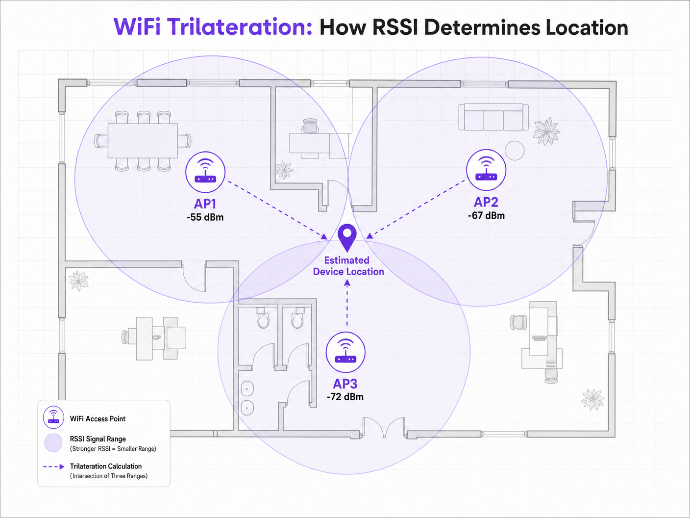
當用戶端裝置(例如廣播探測請求的智慧型手機)被 AP 偵測到時,AP 會記錄 RSSI。由於射頻(RF)訊號在空間中傳播時會衰減(失去功率),因此 RSSI 值可作為距離的替代指標。如果三個或更多 AP 偵測到同一台裝置並記錄其 RSSI,定位引擎就可以計算出與每個 AP 的估算距離,並繪製出虛擬的機率圓。這些圓圈的交點即代表估算的裝置位置。
路徑損耗模型
RSSI 與距離之間的關係並非線性,而是遵循對數路徑損耗模型。定位引擎使用的標準公式為:
RSSI = -10 * n * log10(d) + A
其中:
- d 是與存取點(AP)的距離。
- n 是路徑損耗指數,代表訊號在特定環境中衰減的速度。在自由空間真空中,n 恰好為 2.0。在密集的室內環境中,n 的範圍可能在 3.0 到 4.5 之間。
- A 是在距離 AP 恰好 1 公尺處測得的參考 RSSI。
此公式突顯了為何環境校準至關重要。在具有混凝土牆的 Hospitality 環境中部署,其路徑損耗指數將與寬敞開放的 Retail 賣場顯著不同。在不同環境中皆假設標準的 n 值,是導致導航精確度不佳的主因。
2.4 GHz 與 5 GHz 定位比較
雖然 2.4 GHz 頻段對物理障礙物有較好的穿透力,但此特性實際上不利於精準定位。較大的傳播範圍意味著較大的距離估算圓,進而導致較寬的交會區域和較低的定位解析度。
5 GHz 頻段衰減較快,能提供更緊密的訊號邊界和更細緻的距離估算。為了獲得最佳的導航精確度,定位引擎應優先處理 5 GHz 的 RSSI 數據。此原則也適用於較新的標準;雖然 Wi-Fi 6 提高了整體網路效率,但 RSSI 定位的基本機制仍保持不變,不過在 Wi-Fi 6E 中引入的 6 GHz 頻段提供了更高的通道密度和潛在的解析度優勢。如需了解更多相關資訊,請參閱我們的指南: Wi-Fi 6 vs Wi-Fi 5: Does it Solve Channel Interference? 。
實作指南
存取點密度與配置
導航部署中最常見的失敗模式是 AP 密度不足。純粹為連線設計的網路(例如提供 Guest WiFi 存取)通常缺乏可靠三邊測量所需的密度。
為了實現可靠的定位,用戶端裝置必須同時被至少三個 AP 「聽到」,且 RSSI 需達到 -75 dBm 或更佳。
若要達到 3 到 5 公尺的目標精確度,一般的經驗法則是每 15 到 20 平方公尺部署一台 AP,具體取決於環境。此外,AP 應放置在目標區域的周邊,而不僅僅是沿著走廊中心放置,以確保訊號圓的交點形成一個明確的點,而不是一條直線。
校準方法
準確的距離估算需要針對特定的射頻(RF)環境校準定位引擎。主要有兩種方法:
- RF 指紋定位(RF Fingerprinting): 這涉及攜帶檢測設備實際走訪場域,記錄已知座標處的 RSSI 值,並建立一個完整的對照表。定位引擎隨後會將即時的 RSSI 讀數與該資料庫進行比對。這能提供最高的精確度,但非常耗費人力,且如果物理環境發生變化(例如季節性零售陳列),則必須重複此過程。
- 基於模型的定位(Model-Based Positioning): 此方法使用路徑損耗公式,並結合系統中定義的環境參數(牆壁類型、天花板高度)。它的部署和維護速度更快,雖然精確度略低於指紋定位,但對於區域級分析和大致的導航來說通常已經足夠。
最佳實踐
減輕多路徑干擾
在具有高反射表面的環境中(例如玻璃店面、金屬固定裝置或體育場座椅),RF 訊號會發生折射,透過多條路徑到達接收器。這種多路徑干擾會扭曲 RSSI 讀數,因為接收器測量的是直接訊號和反射訊號的總和,而不是乾淨的視線距離。
減輕多路徑干擾需要結合策略性的 AP 部署(避免高度反射的角落)、嚴格的校準,以及定位引擎內部的智慧過濾演算法,以捨棄異常的 RSSI 突波。
隱私與合規性
透過 MAC 位址收集位置數據時(即使是透過探測請求進行被動收集),IT 團隊也必須確保符合 GDPR 等區域隱私框架。
現代行動作業系統實施的 MAC 位址隨機化,可防止在未經身分驗證的情況下對個人裝置進行長期追蹤。然而,這並不會阻礙整體的客流量分析。為了提供個人化的逐向導航或個人化互動,場域必須取得明確的同意。
這就是整合 Captive Portal 變得至關重要的原因。透過要求使用者進行驗證(例如利用類似 How a wi fi assistant Enables Passwordless Access in 2026 的解決方案),場域營運商可以合法地將裝置與個人進行關聯,並提供加入(opt-in)定位服務。Purple 的平台在 Connect 授權下可作為免費的身分識別提供者,在簡化此合規性要求的同時,提供豐富的 WiFi Analytics 。
疑難排解與風險緩釋
當導航精準度下降時,IT 團隊應系統性地評估以下因素:
- 環境偏移: 場域內是否發生了物理變化(例如新牆面、密集的庫存),導致原始校準失效?
- AP 功率電平: 無線電資源管理 (RRM) 演算法是否在動態調整發射功率?定位引擎依賴穩定的參考點;劇烈的動態功率調整會使距離計算產生偏差。
- 用戶端裝置差異: 不同的智慧型手機製造商使用不同的天線設計,這意味著 Samsung 和 iPhone 在完全相同的位置可能會回報不同的 RSSI 值。先進的定位引擎會使用裝置設定檔來使這些讀數標準化。
投資報酬率與商業影響
部署強大 WiFi 導航的商業案例遠不止於在地圖上顯示一個藍點。對於技術長或場域營運總監而言,投資報酬率是透過營運效率和數據驅動的決策來實現的。
在 Transport 樞紐中,精準的定位能夠根據即時旅客密度進行動態排隊管理和人員調度。在醫療照護環境中,它有助於對高價值醫療設備進行資產追蹤,從而減少採購浪費。
透過在像 Purple 這樣與硬體無關的平台上進行標準化,企業可以提取此定位智慧,而不會被綁定在單一基礎架構廠商中,從而確保長期彈性並最大化其現有無線投資的報酬。正如我們最近的公告 Purple Appoints Iain Fox as VP Growth – Public Sector to Drive Digital Inclusion and Smart City Innovation 中所強調的,此技術的應用正迅速擴展到智慧城市基礎架構中,展現了其可擴展的價值。
Definizioni chiave
RSSI (Received Signal Strength Indicator)
La misurazione della potenza presente in un segnale radio ricevuto, espressa in decibel rispetto a un milliwatt (dBm).
La metrica fondamentale utilizzata dai motori di posizionamento per stimare la distanza tra un dispositivo client e un access point.
Trilaterazione
Il processo di determinazione delle posizioni assolute o relative di punti tramite la misurazione delle distanze, utilizzando la geometria di cerchi, sfere o triangoli.
L'algoritmo matematico utilizzato dai motori di localizzazione per calcolare la posizione di un dispositivo in base alle stime di distanza da più AP.
Esponente di attenuazione del percorso (n)
Una variabile nel modello di propagazione RF che rappresenta la velocità con cui l'intensità del segnale si degrada con la distanza in un ambiente specifico.
Fondamentale per la calibrazione; uno stadio all'aperto avrà un esponente di attenuazione del percorso inferiore rispetto a un ambiente d'ufficio denso con pareti in cemento.
Fingerprinting RF
Una tecnica di calibrazione in cui una sede viene ispezionata fisicamente per registrare i valori RSSI effettivi a coordinate specifiche, creando un database di ricerca.
Utilizzato quando è richiesto un wayfinding ad alta precisione, sebbene comporti elevati costi di manutenzione operativa.
Interferenza multipath
Un fenomeno della fisica radio in cui i segnali RF raggiungono l'antenna ricevente attraverso due o più percorsi a causa della riflessione sulle superfici.
Una delle principali fonti di imprecisione nel wayfinding, in particolare in sedi con vetro, metallo o caratteristiche architettoniche complesse.
Randomizzazione dell'indirizzo MAC
Una funzionalità di privacy nei moderni sistemi operativi mobili in cui il dispositivo trasmette un indirizzo MAC temporaneo e casuale durante le probe request.
Influisce sulla capacità di tracciare i singoli dispositivi nel tempo senza autenticazione di rete, richiedendo alle sedi di adattare le proprie strategie di analytics.
Probe Request
Un frame inviato da un dispositivo client per determinare quali access point si trovano nel raggio d'azione.
Il meccanismo principale per il tracciamento passivo della posizione, che consente agli AP di registrare l'RSSI dei dispositivi anche se non sono connessi alla rete.
Posizionamento basato su modello
Un metodo di calcolo della posizione che si basa su algoritmi matematici e ipotesi ambientali piuttosto che su ispezioni fisiche del sito.
Il modello di implementazione preferito per analytics scalabili e multi-sede in cui l'accuratezza a livello di zona è sufficiente.
Esempi pratici
Un resort hotel da 400 camere riscontra un Wayfinding estremamente impreciso nei corridoi degli ospiti, con il "pallino blu" che salta frequentemente tra piani adiacenti. La rete era stata originariamente progettata per la connettività di base con AP posizionati ogni 30 metri in linea retta al centro dei corridoi.
Il team IT deve riprogettare l'architettura RF per i servizi di localizzazione. In primo luogo, aumentare la densità degli AP a circa uno ogni 15 metri per garantire che un minimo di tre AP possa "sentire" un dispositivo client a -67 dBm o superiore. In secondo luogo, sfalsare il posizionamento degli AP (ad esempio, alternando i lati del corridoio o utilizzando le stanze adiacenti) anziché seguire una linea retta. Un'implementazione in linea retta fa sì che i cerchi di trilaterazione si intersechino in due punti distinti, creando ambiguità. Infine, implementare la calibrazione del fingerprinting RF specificamente nei corridoi per tenere conto dell'elevato esponente di attenuazione causato da porte tagliafuoco e pareti di cemento.
Una grande catena di vendita al dettaglio desidera implementare analisi a livello di zona per misurare il tempo di permanenza nei reparti specifici (ad es. Elettronica vs. Abbigliamento) utilizzando l'infrastruttura Cisco esistente. Desiderano evitare i costi operativi del fingerprinting RF manuale in 50 sedi.
Implementare un motore di posizionamento basato su modelli integrato con i controller LAN wireless Cisco esistenti tramite API. L'architetto di rete dovrebbe definire i parametri ambientali specifici (esponente di attenuazione 'n') per il tipico layout del punto vendita. Assicurarsi che i WLC siano configurati per segnalare i dati RSSI sia dai client associati che da quelli non associati (probe request). Integrare la piattaforma di analytics Purple per consumare questo feed API, mappando le coordinate logiche degli AP sulla planimetria fisica per stabilire le zone analitiche.
Domande di esercitazione
Q1. Stai progettando l'infrastruttura WiFi per un nuovo centro congressi. Il requisito principale è un orientamento (wayfinding) turn-by-turn altamente accurato per i partecipanti. L'architetto propone di posizionare AP ad alta densità esclusivamente al centro dei padiglioni espositivi principali per ridurre al minimo i costi di cablaggio. Approvi questo progetto?
Suggerimento: Considera come i cerchi di trilaterazione si intersecano quando gli AP sono posizionati in un cluster centralizzato rispetto a una distribuzione perimetrale.
Visualizza risposta modello
No, questo progetto deve essere respinto. Per una trilaterazione accurata, gli AP devono essere posizionati sul perimetro dello spazio per fornire diversi angoli di intersezione del segnale. Il posizionamento centralizzato degli AP si tradurrà in cerchi di segnale sovrapposti che non riescono a creare un punto di intersezione definitivo, portando a un'elevata ambiguità di posizione ai bordi del padiglione.
Q2. A seguito di un recente aggiornamento del firmware dei controller LAN wireless, il team operativo segnala che le analisi del tempo di permanenza (dwell time) nei punti vendita al dettaglio sono diventate irregolari, con dispositivi che sembrano "teleportarsi" tra le zone. Non sono state apportate modifiche fisiche ai negozi.
Suggerimento: Considera quali funzionalità automatizzate potrebbe abilitare o alterare un aggiornamento del firmware del WLC per quanto riguarda la gestione RF.
Visualizza risposta modello
Esamina le impostazioni di Radio Resource Management (RRM) o di controllo dinamico della potenza di trasmissione sul WLC. Gli aggiornamenti del firmware spesso alterano l'aggressività di questi algoritmi. Se gli AP fluttuano rapidamente la loro potenza di trasmissione per ottimizzare la connettività, i calcoli della distanza del motore di localizzazione (che si basano su una potenza di riferimento stabile) saranno del tutto distorti, causando l'effetto di "teletrasporto". L'RRM deve essere calibrato per garantire una potenza di trasmissione stabile nelle zone critiche per la localizzazione.
Q3. Il direttore IT di un ospedale desidera tracciare la posizione di costosi ecografi mobili. Attualmente dispongono di una rete WiFi legacy progettata per una copertura di base (minimo -75 dBm). Sono indecisi se aggiornare la rete WiFi per servizi di localizzazione ad alta densità o implementare una rete parallela di beacon BLE (Bluetooth Low Energy).
Suggerimento: Valuta i compromessi in termini di costi e accuratezza tra l'aggiornamento di una rete WiFi legacy e l'aggiunta di una soluzione BLE mirata per il tracciamento delle risorse.
Visualizza risposta modello
Per un tracciamento preciso delle risorse (ad esempio, sapere esattamente in quale stanza si trova un macchinario), il BLE è spesso la soluzione più conveniente e accurata in questo scenario. L'aggiornamento di una rete WiFi legacy alla densità richiesta per l'orientamento ad alta precisione (1 AP ogni 15 mq) richiede investimenti significativi in cablaggio e hardware. L'installazione di beacon BLE alimentati a batteria sulle risorse e di ricevitori BLE nelle stanze offre una maggiore precisione (grazie alla portata inferiore e alla minore potenza) senza interrompere l'infrastruttura WiFi esistente.
Continua a leggere questa serie
Marketing basata su dati di prima parte: una guida completa per le aziende
Questa guida spiega come creare una solida strategia di marketing basata su dati di prima parte utilizzando reti Guest WiFi aziendali. Copre l'architettura tecnica per l'acquisizione sicura dei dati tramite Captive Portal, flussi di lavoro di consenso conformi al GDPR, modelli di integrazione CRM e implementazione automatizzata delle campagne. I gestori di location nei settori hospitality, retail, eventi e pubblica amministrazione troveranno indicazioni pratiche per trasformare i visitatori passivi in un pubblico di marketing di proprietà e di alta qualità.
Piattaforma di gestione dei dati dei clienti: una guida completa per le aziende
Questa guida spiega come i gestori di location possono implementare una piattaforma di gestione dei dati dei clienti per unificare i dati frammentati dei visitatori. Copre l'architettura tecnica, le strategie di integrazione e il ruolo fondamentale del Guest WiFi nella creazione di profili di dati di prima parte.
Misurare il ROI aziendale del Guest WiFi e della Location Analytics
Questa guida fornisce un framework tecnico e operativo per misurare il ROI aziendale del guest WiFi e della location analytics. Descrive in dettaglio come calcolare il valore degli investimenti hardware attraverso l'aumento del tempo di permanenza (dwell time), l'efficienza operativa e l'acquisizione di dati di prima parte nei settori retail, hospitality e spazi pubblici. I manager IT, gli architetti di rete, i CTO e i direttori delle operazioni delle strutture troveranno framework di misurazione concreti, casi di studio reali e linee guida di conformità per giustificare e massimizzare il proprio investimento nel WiFi.