
The Mechanics of WiFi Wayfinding: Trilateration and RSSI Explained

This authoritative guide details the technical mechanics of WiFi wayfinding, explaining how trilateration and RSSI measurements determine device location. It provides actionable deployment strategies, calibration methodologies, and architectural best practices for IT leaders deploying location services in enterprise venues.

📖 6 min read📝 1,319 words🔧 2 worked examples3 practice questions📚 8 key definitions

Listen to this guide

View podcast transcript
THE MECHANICS OF WIFI WAYFINDING: TRILATERATION AND RSSI EXPLAINED A Purple Technical Briefing Podcast — Approximately 10 Minutes --- SEGMENT 1: INTRODUCTION AND CONTEXT (approx. 1 minute) Welcome to the Purple Technical Briefing series. I'm your host, and today we're getting into the mechanics of WiFi wayfinding — specifically how trilateration and RSSI work together to tell you where someone is inside a building, and what that means for your deployment strategy. If you're a network architect, IT manager, or venue operations director, this is the episode for you. We're not going to spend time on the basics of WiFi — you know what an access point is. What we're going to cover is the positioning layer that sits on top of your existing infrastructure, how it actually works under the hood, and the practical decisions you need to make to get it right. The question "what is wayfinding?" comes up constantly in enterprise WiFi conversations, and the honest answer is: it's a lot more nuanced than most vendors let on. So let's get into it. --- SEGMENT 2: TECHNICAL DEEP-DIVE (approx. 5 minutes) Let's start with the fundamentals. WiFi wayfinding is the use of your existing wireless infrastructure to determine the physical location of a device — and by extension, the person carrying it — inside a venue. No GPS, no additional hardware in most cases, just the access points you already have. The core mechanism is trilateration. Not triangulation — that's a common misconception worth clearing up immediately. Triangulation uses angles. Trilateration uses distances. Your access points measure signal strength from a device, convert that signal strength into an estimated distance, and then the system calculates where those distance circles intersect. That intersection is your device's estimated position. The signal strength measurement is called RSSI — Received Signal Strength Indicator. It's expressed in decibels relative to a milliwatt, or dBm. The scale runs from zero, which would be an impossibly strong signal, down to around minus 100 dBm, which is effectively noise. For practical wayfinding deployments, you want your access points seeing client devices at minus 67 dBm or better. Below minus 75, you're in unreliable territory. Below minus 85, forget it — you won't get consistent positioning. Now, here's where it gets technically interesting. The relationship between RSSI and distance is not linear. It follows a logarithmic path-loss model. The standard formula is: RSSI equals minus 10 times n times the log base 10 of distance, plus a constant A. Where n is the path-loss exponent — typically between 2 and 4 depending on your environment — and A is the RSSI at one metre from the access point, your calibration reference. In an open office with line of sight, n might be 2.0. In a dense hotel corridor with concrete walls, steel doors, and lift shafts, n could be 3.5 or higher. This is why a deployment that works brilliantly in one venue can give you 10-metre errors in another with the same AP density. The environment is a variable, and it has to be measured, not assumed. This brings us to calibration. There are two approaches. The first is radio frequency fingerprinting — you physically walk the space with a device, recording RSSI values at known coordinates, and build a lookup table. Accurate, but labour-intensive, and it needs to be redone whenever the physical environment changes significantly. The second is model-based positioning, where you apply the path-loss formula with measured or estimated environmental parameters. Faster to deploy, less accurate, but sufficient for zone-level wayfinding in most venue types. For precision wayfinding — think hospital ward-level accuracy, or retail shelf-level product guidance — you typically need a hybrid approach, combining WiFi RSSI with additional signals. Bluetooth Low Energy beacons are the most common complement. BLE operates at shorter range and lower power, which means tighter signal circles and better intersection accuracy. The IEEE 802.11mc standard, also known as WiFi Round-Trip Time or RTT, is another option — it measures the actual time of flight of the signal rather than just its strength, giving you distance estimates that are far less susceptible to environmental interference. But RTT requires compatible hardware on both the AP and the client device, so check your estate before specifying it. Now let's talk about the positioning stack architecture. At the bottom, you have your physical layer — the access points, their placement, and their antenna characteristics. Above that, you have the RSSI collection layer, which is typically handled either by your wireless controller or by a dedicated location engine. Then you have the positioning engine itself, which runs the trilateration calculations and applies any calibration data or machine learning corrections. Above that sits the application layer — the wayfinding interface that the end user actually sees, whether that's a map on their phone, a digital signage display, or an analytics dashboard showing dwell time and footfall patterns. Purple's platform operates at the application and analytics layer, consuming positioning data from your existing infrastructure — whether that's Cisco, Aruba, Ruckus, or any other vendor — and translating it into actionable intelligence. That hardware-agnostic approach is significant because it means you're not locked into a single vendor's location engine, and you can evolve your underlying infrastructure without rebuilding your wayfinding application. One more technical point worth covering: the impact of the 2.4 GHz versus 5 GHz band on positioning accuracy. The 2.4 GHz band propagates further and penetrates walls better, which sounds like an advantage for coverage. But for positioning, that propagation characteristic actually works against you — the signal circles are larger, which means the intersection area is larger, which means lower precision. The 5 GHz band attenuates faster, giving you tighter circles and better positional resolution. For wayfinding deployments, you generally want your positioning engine consuming 5 GHz RSSI data where available, with 2.4 GHz as a fallback. --- SEGMENT 3: IMPLEMENTATION RECOMMENDATIONS AND PITFALLS (approx. 2 minutes) Right, let's get practical. The three most common failure modes I see in wayfinding deployments are: insufficient AP density, poor calibration, and ignoring multipath interference. On AP density: the rule of thumb is that for reliable trilateration you need a minimum of three access points with overlapping coverage at any given point in the venue. In practice, for a 2 to 3 metre accuracy target, you're looking at one AP per 15 to 20 square metres in a typical indoor environment. That's denser than you'd deploy purely for connectivity, which means wayfinding requirements should feed into your RF design from day one, not be bolted on afterwards. On calibration: do not skip the site survey. Even if you're using a model-based approach, you need measured path-loss exponents for your specific environment. A 30-minute walk-through with a spectrum analyser will save you weeks of troubleshooting inaccurate positioning post-deployment. On multipath: this is the big one that catches people out. In environments with lots of reflective surfaces — think glass-fronted retail, airport terminals, sports halls — signals bounce off walls and floors and arrive at the receiver via multiple paths. The RSSI reading becomes an average of all those paths, not a clean line-of-sight measurement. The mitigation is a combination of denser AP deployment, fingerprinting calibration, and — where budget allows — the move to RTT-based positioning which is inherently more resistant to multipath because it's measuring time, not amplitude. From a compliance perspective: if you're collecting location data on individuals, you're in scope for GDPR in the UK and EU. The key principle is that passive RSSI collection from probe requests — where the device is broadcasting its MAC address — is generally considered personal data processing. You need a lawful basis, typically legitimate interests for aggregate analytics, or explicit consent for individual-level tracking. MAC address randomisation, which is now default on iOS 14 and above and Android 10 and above, significantly complicates individual tracking but doesn't affect aggregate footfall analytics. --- SEGMENT 4: RAPID-FIRE Q&A (approx. 1 minute) A few questions that come up regularly: "Do I need to upgrade my access points for wayfinding?" — In most cases, no. If your APs are less than five years old and running a current firmware, they'll support RSSI reporting. RTT-based positioning is the exception — that requires 802.11mc-compatible hardware. "What accuracy can I realistically expect?" — For a well-calibrated WiFi-only deployment, 3 to 5 metres is a realistic target. Add BLE beacons and you can get to 1 to 2 metres. RTT can get you under 1 metre in favourable conditions. "How does this work with Wi-Fi 6?" — Wi-Fi 6 and Wi-Fi 6E improve throughput and reduce latency, but they don't fundamentally change the RSSI-based positioning model. The higher channel density in 6 GHz does offer some positioning benefits in terms of signal resolution. We've covered the Wi-Fi 6 versus Wi-Fi 5 comparison in detail in our guides section if you want to go deeper on that. "What about privacy?" — Aggregate zone analytics don't require individual identification. If you're doing individual wayfinding — turn-by-turn navigation — you need explicit opt-in. Purple's guest WiFi platform handles the consent capture at the point of network authentication. --- SEGMENT 5: SUMMARY AND NEXT STEPS (approx. 1 minute) To wrap up: WiFi wayfinding is a mature, deployable technology that works on your existing infrastructure. The core mechanic is trilateration using RSSI measurements — three or more access points, distance estimation via path-loss modelling, and intersection calculation to determine device position. The accuracy you achieve is directly proportional to your AP density, the quality of your calibration, and your ability to account for environmental variables like multipath and wall attenuation. For most venue operators — hotels, retail, stadiums, conference centres — a well-designed WiFi wayfinding deployment will deliver 3 to 5 metre accuracy, which is more than sufficient for turn-by-turn navigation, zone-level dwell analytics, and operational use cases like staff location and asset tracking. The next step is a site assessment. Map your current AP placement against the density requirements for your target accuracy, identify the calibration approach that fits your operational model, and make sure your data collection practices are GDPR-compliant from day one. Purple's platform integrates with your existing infrastructure to deliver the analytics and wayfinding application layer on top. If you want to explore what that looks like for your specific venue, the details are at purple.ai. Thanks for listening. We'll be back with the next technical briefing shortly. --- END OF SCRIPT

header_image.png

執行摘要

對於企業級場域營運商而言,部署有效的室內定位服務不僅僅是在空間中佈滿基地台。WiFi 導航的基本機制——三邊測量(Trilateration)與接收訊號強度指示(RSSI)量測——決定了任何成功部署的架構要求。本指南深入探討了您現有的無線基礎設施如何確定裝置位置的技術原理、影響精準度的關鍵環境變數,以及提供可靠定位智慧所需的部署標準。

理解這些機制對於負責提供循序導航、資產追蹤或人流量分析的 IT 經理和網路架構師至關重要。我們將探討訊號強度與距離之間的對數關係、嚴格校準的必要性,以及如何整合如 Purple 等與硬體無關的分析平台,從您的射頻(RF)環境中提取具備商業價值的洞察。

收聽我們的隨附播客簡報:

技術深度探討

RSSI 與三邊測量的基本原理

WiFi 導航的核心是依賴現有的無線基礎設施來確定用戶端裝置的物理位置。其主要機制是三邊測量,這經常被錯誤地稱為三角測量(Triangulation)。三角測量是根據角度計算位置,而三邊測量則是透過測量與已知參考點的距離來確定位置。

在 WiFi 的情境中,這些參考點就是您的存取點(AP)。距離估算是源自於接收訊號強度指示 (RSSI)。RSSI 是對接收到的無線電訊號中存在之功率的量測,以相對於毫瓦的分貝(dBm)表示。

trilateration_diagram.png

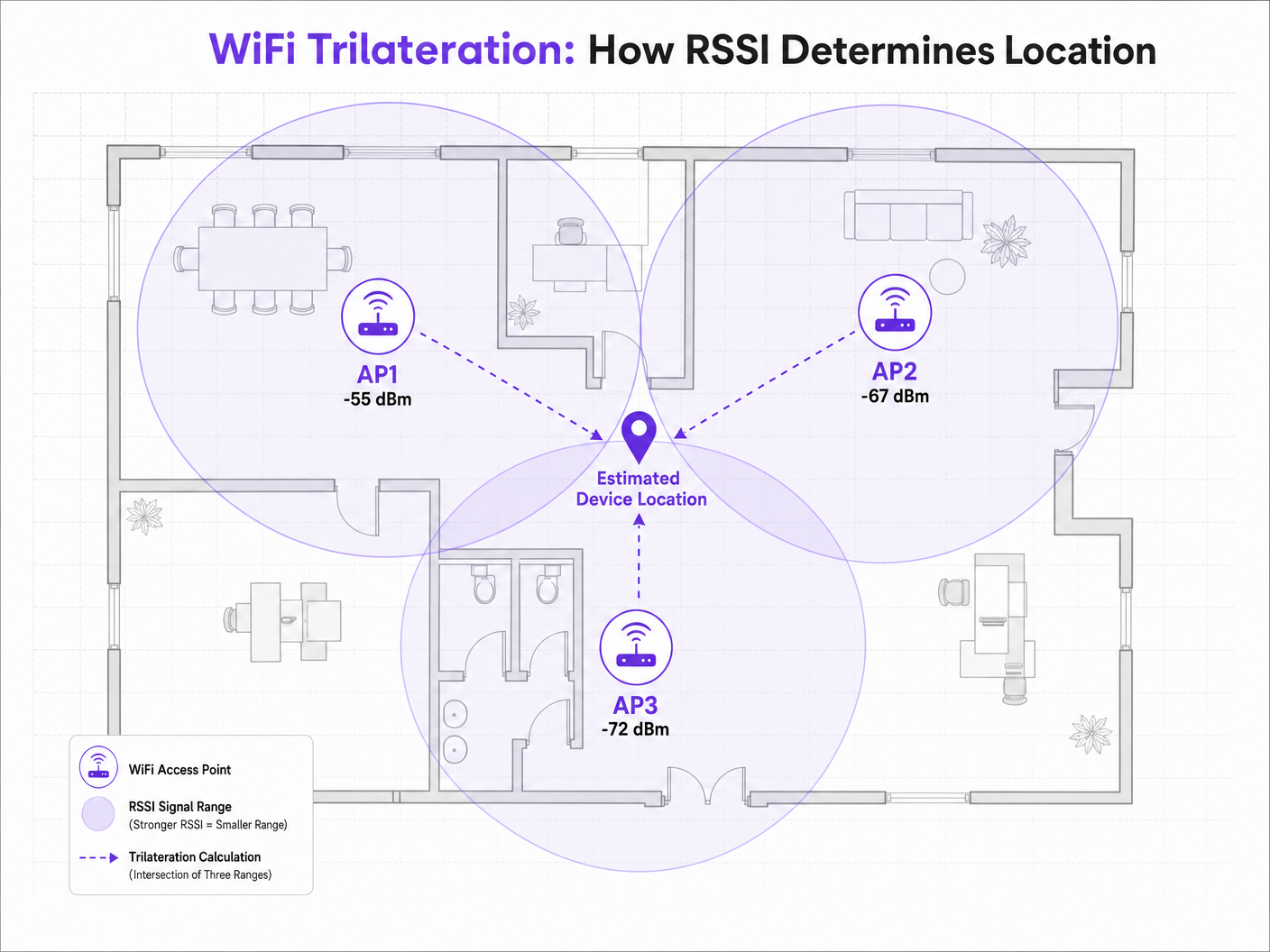
當用戶端裝置(例如廣播探測請求的智慧型手機)被 AP 偵測到時,AP 會記錄 RSSI。由於射頻(RF)訊號在空間中傳播時會衰減(失去功率),因此 RSSI 值可作為距離的替代指標。如果三個或更多 AP 偵測到同一台裝置並記錄其 RSSI,定位引擎就可以計算出與每個 AP 的估算距離,並繪製出虛擬的機率圓。這些圓圈的交點即代表估算的裝置位置。

路徑損耗模型

RSSI 與距離之間的關係並非線性,而是遵循對數路徑損耗模型。定位引擎使用的標準公式為:

RSSI = -10 * n * log10(d) + A

其中:

  • d 是與存取點(AP)的距離。
  • n 是路徑損耗指數,代表訊號在特定環境中衰減的速度。在自由空間真空中,n 恰好為 2.0。在密集的室內環境中,n 的範圍可能在 3.0 到 4.5 之間。
  • A 是在距離 AP 恰好 1 公尺處測得的參考 RSSI。

此公式突顯了為何環境校準至關重要。在具有混凝土牆的 Hospitality 環境中部署,其路徑損耗指數將與寬敞開放的 Retail 賣場顯著不同。在不同環境中皆假設標準的 n 值,是導致導航精確度不佳的主因。

2.4 GHz 與 5 GHz 定位比較

雖然 2.4 GHz 頻段對物理障礙物有較好的穿透力,但此特性實際上不利於精準定位。較大的傳播範圍意味著較大的距離估算圓,進而導致較寬的交會區域和較低的定位解析度。

5 GHz 頻段衰減較快,能提供更緊密的訊號邊界和更細緻的距離估算。為了獲得最佳的導航精確度,定位引擎應優先處理 5 GHz 的 RSSI 數據。此原則也適用於較新的標準;雖然 Wi-Fi 6 提高了整體網路效率,但 RSSI 定位的基本機制仍保持不變,不過在 Wi-Fi 6E 中引入的 6 GHz 頻段提供了更高的通道密度和潛在的解析度優勢。如需了解更多相關資訊,請參閱我們的指南: Wi-Fi 6 vs Wi-Fi 5: Does it Solve Channel Interference?

實作指南

存取點密度與配置

導航部署中最常見的失敗模式是 AP 密度不足。純粹為連線設計的網路(例如提供 Guest WiFi 存取)通常缺乏可靠三邊測量所需的密度。

為了實現可靠的定位,用戶端裝置必須同時被至少三個 AP 「聽到」,且 RSSI 需達到 -75 dBm 或更佳。rssi_reference_chart.png

若要達到 3 到 5 公尺的目標精確度,一般的經驗法則是每 15 到 20 平方公尺部署一台 AP,具體取決於環境。此外,AP 應放置在目標區域的周邊,而不僅僅是沿著走廊中心放置,以確保訊號圓的交點形成一個明確的點,而不是一條直線。

校準方法

準確的距離估算需要針對特定的射頻(RF)環境校準定位引擎。主要有兩種方法:

  1. RF 指紋定位(RF Fingerprinting): 這涉及攜帶檢測設備實際走訪場域,記錄已知座標處的 RSSI 值,並建立一個完整的對照表。定位引擎隨後會將即時的 RSSI 讀數與該資料庫進行比對。這能提供最高的精確度,但非常耗費人力,且如果物理環境發生變化(例如季節性零售陳列),則必須重複此過程。
  2. 基於模型的定位(Model-Based Positioning): 此方法使用路徑損耗公式,並結合系統中定義的環境參數(牆壁類型、天花板高度)。它的部署和維護速度更快,雖然精確度略低於指紋定位,但對於區域級分析和大致的導航來說通常已經足夠。

最佳實踐

減輕多路徑干擾

在具有高反射表面的環境中(例如玻璃店面、金屬固定裝置或體育場座椅),RF 訊號會發生折射,透過多條路徑到達接收器。這種多路徑干擾會扭曲 RSSI 讀數,因為接收器測量的是直接訊號和反射訊號的總和,而不是乾淨的視線距離。

減輕多路徑干擾需要結合策略性的 AP 部署(避免高度反射的角落)、嚴格的校準,以及定位引擎內部的智慧過濾演算法,以捨棄異常的 RSSI 突波。

隱私與合規性

透過 MAC 位址收集位置數據時(即使是透過探測請求進行被動收集),IT 團隊也必須確保符合 GDPR 等區域隱私框架。

現代行動作業系統實施的 MAC 位址隨機化,可防止在未經身分驗證的情況下對個人裝置進行長期追蹤。然而,這並不會阻礙整體的客流量分析。為了提供個人化的逐向導航或個人化互動,場域必須取得明確的同意。

這就是整合 Captive Portal 變得至關重要的原因。透過要求使用者進行驗證(例如利用類似 How a wi fi assistant Enables Passwordless Access in 2026 的解決方案),場域營運商可以合法地將裝置與個人進行關聯,並提供加入(opt-in)定位服務。Purple 的平台在 Connect 授權下可作為免費的身分識別提供者,在簡化此合規性要求的同時,提供豐富的 WiFi Analytics

疑難排解與風險緩釋

當導航精準度下降時,IT 團隊應系統性地評估以下因素:

  • 環境偏移: 場域內是否發生了物理變化(例如新牆面、密集的庫存),導致原始校準失效?
  • AP 功率電平: 無線電資源管理 (RRM) 演算法是否在動態調整發射功率?定位引擎依賴穩定的參考點;劇烈的動態功率調整會使距離計算產生偏差。
  • 用戶端裝置差異: 不同的智慧型手機製造商使用不同的天線設計,這意味著 Samsung 和 iPhone 在完全相同的位置可能會回報不同的 RSSI 值。先進的定位引擎會使用裝置設定檔來使這些讀數標準化。

投資報酬率與商業影響

部署強大 WiFi 導航的商業案例遠不止於在地圖上顯示一個藍點。對於技術長或場域營運總監而言,投資報酬率是透過營運效率和數據驅動的決策來實現的。

Transport 樞紐中,精準的定位能夠根據即時旅客密度進行動態排隊管理和人員調度。在醫療照護環境中,它有助於對高價值醫療設備進行資產追蹤,從而減少採購浪費。

透過在像 Purple 這樣與硬體無關的平台上進行標準化,企業可以提取此定位智慧,而不會被綁定在單一基礎架構廠商中,從而確保長期彈性並最大化其現有無線投資的報酬。正如我們最近的公告 Purple Appoints Iain Fox as VP Growth – Public Sector to Drive Digital Inclusion and Smart City Innovation 中所強調的,此技術的應用正迅速擴展到智慧城市基礎架構中,展現了其可擴展的價值。

Key Definitions

RSSI (Received Signal Strength Indicator)

A measurement of the power present in a received radio signal, expressed in decibels relative to a milliwatt (dBm).

The fundamental metric used by positioning engines to estimate the distance between a client device and an access point.

Trilateration

The process of determining absolute or relative locations of points by measurement of distances, using the geometry of circles, spheres or triangles.

The mathematical algorithm used by location engines to calculate a device's position based on distance estimates from multiple APs.

Path-Loss Exponent (n)

A variable in the RF propagation model that represents the rate at which signal strength degrades over distance in a specific environment.

Critical for calibration; an open stadium will have a lower path-loss exponent than a dense office environment with concrete walls.

RF Fingerprinting

A calibration technique where a venue is physically surveyed to record actual RSSI values at specific coordinates, creating a lookup database.

Used when high-precision wayfinding is required, though it carries a high operational maintenance cost.

Multipath Interference

A phenomenon in radio physics where RF signals reach the receiving antenna by two or more paths due to reflection off surfaces.

A major source of inaccuracy in wayfinding, particularly in venues with glass, metal, or complex architectural features.

MAC Address Randomisation

A privacy feature in modern mobile OS where the device broadcasts a temporary, randomized MAC address during probe requests.

Impacts the ability to track individual devices over time without network authentication, requiring venues to adapt their analytics strategies.

Probe Request

A frame sent by a client device to determine which access points are within range.

The primary mechanism for passive location tracking, allowing APs to record the RSSI of devices even if they are not connected to the network.

Model-Based Positioning

A location calculation method that relies on mathematical algorithms and environmental assumptions rather than physical site surveys.

The preferred deployment model for scalable, multi-site analytics where zone-level accuracy is sufficient.

Worked Examples

A 400-room resort hotel is experiencing highly inaccurate wayfinding in its guest corridors, with the 'blue dot' frequently jumping between adjacent floors. The network was originally designed for basic connectivity with APs placed every 30 metres in a straight line down the centre of the hallways.

The IT team must redesign the RF architecture for location services. First, increase AP density to approximately one every 15 metres to ensure a minimum of three APs can 'hear' a client device at -67 dBm or better. Second, stagger the AP placement (e.g., alternating sides of the corridor or utilizing adjacent rooms) rather than a straight line. A straight-line deployment causes the trilateration circles to intersect at two distinct points, creating ambiguity. Finally, implement RF fingerprinting calibration specifically in the corridors to account for the high path-loss exponent caused by fire doors and concrete walls.

Examiner's Commentary: This scenario highlights the difference between coverage design and capacity/location design. The 'jumping' between floors is a classic symptom of poor vertical attenuation mapping and insufficient horizontal AP density. Staggering the APs resolves the linear ambiguity problem inherent in basic trilateration.

A large retail chain wants to deploy zone-level analytics to measure dwell time in specific departments (e.g., Electronics vs. Apparel) using their existing Cisco infrastructure. They want to avoid the operational overhead of manual RF fingerprinting across 50 locations.

Deploy a model-based positioning engine integrated with the existing Cisco wireless LAN controllers via API. The network architect should define the specific environmental parameters (path-loss exponent 'n') for the typical retail floor layout. Ensure that the WLCs are configured to report RSSI data from both associated and unassociated clients (probe requests). Overlay the Purple analytics platform to consume this API feed, mapping the logical AP coordinates to the physical floor plan to establish the analytical zones.

Examiner's Commentary: For zone-level analytics, absolute pinpoint accuracy is less critical than broad reliability. Model-based positioning is the correct architectural choice here, balancing acceptable accuracy (3-5m) with the scalability required for a 50-site deployment. The hardware-agnostic approach prevents vendor lock-in.

Practice Questions

Q1. You are designing the WiFi infrastructure for a new conference centre. The primary requirement is highly accurate turn-by-turn wayfinding for attendees. The architect proposes placing high-density APs exclusively in the centre of the main exhibition halls to minimize cabling costs. Do you approve this design?

Hint: Consider how trilateration circles intersect when APs are placed in a centralized cluster versus a perimeter deployment.

View model answer

No, this design should be rejected. For accurate trilateration, APs must be placed on the perimeter of the space to provide diverse angles of signal intersection. Centralized AP placement will result in overlapping signal circles that fail to create a definitive intersection point, leading to high positional ambiguity at the edges of the hall.

Q2. Following a recent firmware update to your wireless LAN controllers, the operations team reports that the dwell time analytics in the retail stores have become erratic, with devices appearing to 'teleport' between zones. No physical changes have been made to the stores.

Hint: Consider what automated features a WLC firmware update might enable or alter regarding RF management.

View model answer

Investigate the Radio Resource Management (RRM) or dynamic transmit power control settings on the WLC. Firmware updates often alter the aggressiveness of these algorithms. If the APs are rapidly fluctuating their transmit power to optimize connectivity, the location engine's distance calculations (which rely on a stable reference power) will be entirely skewed, causing the 'teleporting' effect. RRM should be tuned to ensure stable transmit power in location-critical zones.

Q3. A hospital IT director wants to track the location of expensive mobile ultrasound machines. They currently have a legacy WiFi network designed for basic coverage (-75 dBm minimum). They are debating between upgrading the WiFi network for high-density location services or deploying a parallel BLE (Bluetooth Low Energy) beacon network.

Hint: Evaluate the cost and accuracy trade-offs between upgrading a legacy WiFi network versus overlaying a targeted BLE solution for asset tracking.

View model answer

For precise asset tracking (e.g., knowing exactly which room a machine is in), BLE is often the more cost-effective and accurate solution in this scenario. Upgrading a legacy WiFi network to the density required for high-precision wayfinding (1 AP per 15 sqm) requires significant cabling and hardware investment. Deploying battery-powered BLE beacons on the assets and BLE receivers in the rooms provides higher accuracy (due to shorter range and lower power) without disrupting the existing WiFi infrastructure.