A Mecânica da Localização por WiFi: Trilateração e RSSI Explicados
Este guia autorizado detalha a mecânica técnica da localização por WiFi, explicando como as medições de trilateração e RSSI determinam a localização do dispositivo. Fornece estratégias de implementação acionáveis, metodologias de calibração e melhores práticas arquitetónicas para líderes de TI que implementam serviços de localização em espaços empresariais.
Ouça este guia
Ver transcrição do podcast

Resumo Executivo
Para operadores de espaços empresariais, a implementação de serviços de localização indoor eficazes exige mais do que apenas cobrir um espaço com pontos de acesso. A mecânica fundamental da localização por WiFi — trilateração e medições do Indicador de Força do Sinal Recebido (RSSI) — dita os requisitos arquitetónicos para qualquer implementação bem-sucedida. Este guia oferece uma análise aprofundada dos princípios técnicos de como a sua infraestrutura sem fios existente determina a posição do dispositivo, as variáveis ambientais críticas que afetam a precisão e os padrões de implementação necessários para fornecer inteligência de localização fiável.
Compreender esta mecânica é essencial para gestores de TI e arquitetos de rede encarregados de fornecer navegação passo a passo, rastreamento de ativos ou análise de fluxo de pessoas. Exploramos a relação logarítmica entre a força do sinal e a distância, a necessidade de calibração rigorosa e a integração de plataformas de análise independentes de hardware como a Purple para extrair valor de negócio acionável do seu ambiente de RF.
Ouça o nosso briefing de podcast complementar:
Análise Técnica Aprofundada
Os Fundamentos de RSSI e Trilateração
Na sua essência, a localização por WiFi depende da infraestrutura sem fios existente para determinar a localização física de um dispositivo cliente. O mecanismo principal para isso é a trilateração, que é frequentemente, e incorretamente, referida como triangulação. Enquanto a triangulação calcula a posição com base em ângulos, a trilateração determina a posição medindo distâncias a partir de pontos de referência conhecidos.
Num contexto WiFi, estes pontos de referência são os seus pontos de acesso (APs). A estimativa de distância é derivada do Indicador de Força do Sinal Recebido (RSSI). RSSI é uma medição da potência presente num sinal de rádio recebido, expressa em decibéis em relação a um miliwatt (dBm).
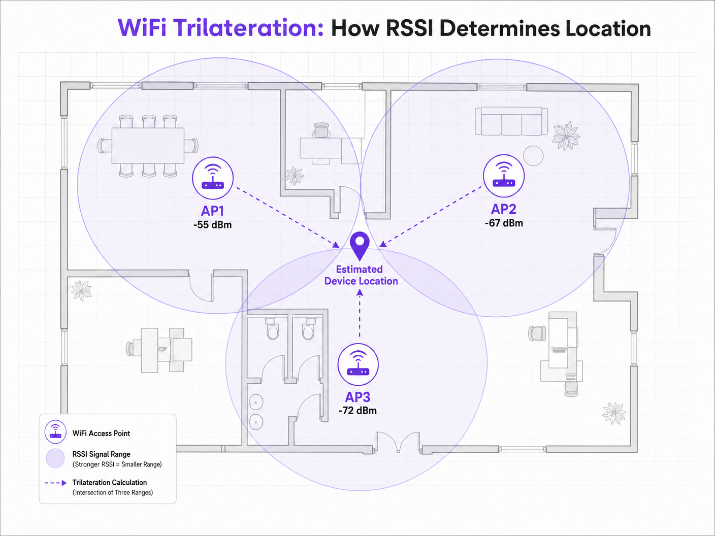
Quando um dispositivo cliente — como um smartphone a transmitir pedidos de sonda — é detetado por um AP, o AP regista o RSSI. Como os sinais de radiofrequência (RF) atenuam (perdem potência) à medida que viajam pelo espaço, o valor RSSI serve como um proxy para a distância. Se três ou mais APs detetarem o mesmo dispositivo e registarem o seu RSSI, o motor de posicionamento pode calcular a distância estimada de cada AP, desenhando círculos virtuais de probabilidade. A interseção destes círculos representa a localização estimada do dispositivo.
O Modelo de Perda de Trajeto
A relação entre RSSI e distância não é linear; segue um modelo logarítmico de perda de trajeto. A fórmula padrão usada pelos motores de posicionamento é:
RSSI = -10 * n * log10(d) + A
Onde:
- d é a distância do ponto de acesso.
- n é o expoente de perda de trajeto, representando a rapidez com que o sinal se degrada no ambiente específico. Num vácuo de espaço livre, n é exatamente 2.0. Em ambientes indoor densos, n pode variar de 3.0 a 4.5.
- A é o RSSI de referência medido a exatamente 1 metro do AP.
Esta fórmula destaca porque a calibração ambiental é crítica. Uma implementação num ambiente de Hotelaria com paredes de betão terá um expoente de perda de trajeto significativamente diferente de um piso de Retalho amplo e aberto. Assumir um valor n padrão em diversos ambientes é a principal causa de baixa precisão na localização.
2.4 GHz vs 5 GHz para Posicionamento
Embora a banda de 2.4 GHz ofereça melhor penetração através de obstáculos físicos, esta característica é, na verdade, prejudicial para o posicionamento de precisão. A maior pegada de propagação significa círculos de estimativa de distância maiores, resultando numa área de interseção mais ampla e menor resolução posicional.
A banda de 5 GHz atenua mais rapidamente, fornecendo limites de sinal mais apertados e estimativas de distância mais granulares. Para uma precisão de localização ótima, os motores de posicionamento devem priorizar os dados RSSI de 5 GHz. Este princípio também se aplica a padrões mais recentes; embora o Wi-Fi 6 melhore a eficiência geral da rede, a mecânica fundamental do posicionamento RSSI permanece a mesma, embora a introdução da banda de 6 GHz no Wi-Fi 6E ofereça uma densidade de canal ainda maior e potenciais benefícios de resolução. Para mais informações sobre este assunto, consulte o nosso guia: Wi-Fi 6 vs Wi-Fi 5: Does it Solve Channel Interference? .
Guia de Implementação
Densidade e Colocação de Pontos de Acesso
O modo de falha mais comum em implementações de localização é a densidade insuficiente de AP. Uma rede projetada puramente para conectividade (por exemplo, fornecendo acesso Guest WiFi ) muitas vezes carece da densidade necessária para uma trilateração fiável.
Para um posicionamento fiável, um dispositivo cliente deve ser "ouvido" por um mínimo de três APs simultaneamente com um RSSI de -75 dBm ou melhor.
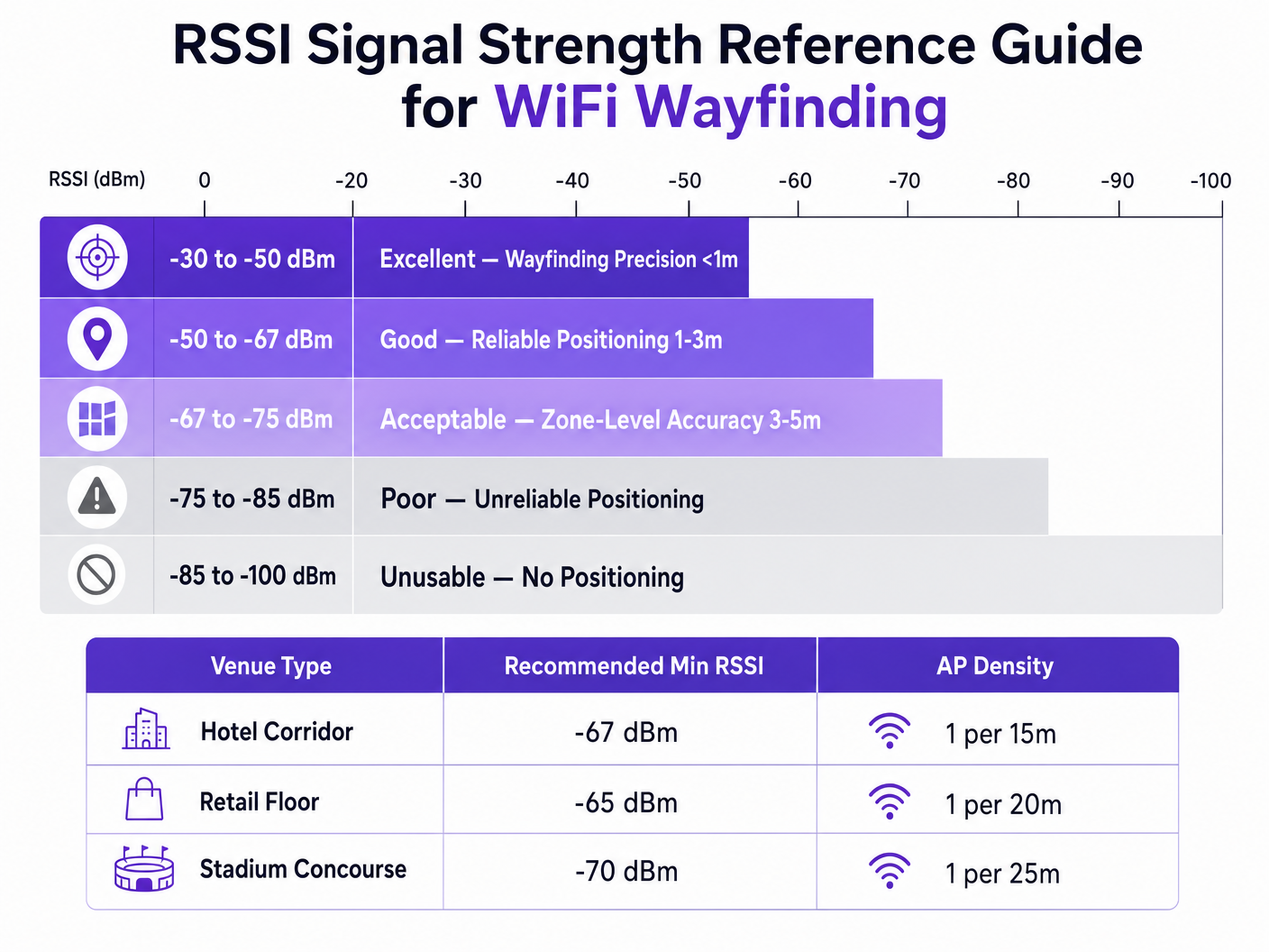
Para alcançar uma precisão alvo de 3 a 5 metros, uma regra geral é implementar um AP por cada 15 a 20 metros quadrados, dependendo do ambiente. Além disso, os APs devem ser colocados no perímetro da área alvo, não apenas no centro de um corredor, para garantir que a interseção dos círculos de sinal crie um ponto definitivo em vez de uma linha reta.
Metodologias de Calibração
Precisa distaA estimativa de localização requer a calibração do motor de posicionamento para o ambiente de RF específico. Existem duas abordagens principais:
- RF Fingerprinting: Isto envolve percorrer fisicamente o local com um dispositivo de levantamento, registar os valores de RSSI em coordenadas conhecidas e construir uma tabela de pesquisa abrangente. O motor de posicionamento compara então as leituras de RSSI em tempo real com esta base de dados. Isto proporciona a mais alta precisão, mas é altamente intensivo em mão de obra e deve ser repetido se o ambiente físico mudar (por exemplo, expositores de retalho sazonais).
- Posicionamento Baseado em Modelo: Esta abordagem utiliza a fórmula de perda de percurso combinada com parâmetros ambientais (tipos de parede, alturas de teto) definidos no sistema. É mais rápido de implementar e manter e, embora ligeiramente menos preciso do que o fingerprinting, é geralmente suficiente para análises ao nível da zona e orientação geral.
Melhores Práticas
Mitigação de Interferência Multipath
Em ambientes com superfícies altamente refletoras — como montras de vidro, acessórios de metal ou assentos de estádio — os sinais de RF saltam, chegando ao recetor por múltiplos caminhos. Esta interferência multipath distorce a leitura de RSSI, uma vez que o recetor mede um agregado dos sinais diretos e refletidos, em vez da distância limpa em linha de visão.
A mitigação de multipath requer uma combinação de colocação estratégica de AP (evitando cantos altamente refletores), calibração rigorosa e algoritmos de filtragem inteligentes dentro do motor de posicionamento que podem descartar picos anómalos de RSSI.
Privacidade e Conformidade
Ao recolher dados de localização via endereços MAC (mesmo passivamente através de pedidos de sonda), as equipas de TI devem garantir a conformidade com os quadros de privacidade regionais como o GDPR.
A implementação da aleatorização de endereços MAC por sistemas operativos móveis modernos impede o rastreamento a longo prazo de dispositivos individuais sem autenticação. No entanto, não impede a análise agregada de fluxo de visitantes. Para fornecer orientação individual passo a passo ou envolvimento personalizado, os locais devem obter consentimento explícito.
É aqui que a integração de um Captive Portal se torna essencial. Ao exigir que os utilizadores se autentiquem — talvez aproveitando uma solução como How a wi fi assistant Enables Passwordless Access in 2026 — os locais podem associar legalmente um dispositivo a um indivíduo e fornecer serviços de localização com consentimento. A plataforma Purple atua como um fornecedor de identidade gratuito sob a licença Connect, simplificando este requisito de conformidade enquanto oferece WiFi Analytics ricos.
Resolução de Problemas e Mitigação de Riscos
Quando a precisão da orientação se degrada, as equipas de TI devem avaliar sistematicamente os seguintes vetores:
- Deriva Ambiental: Ocorreram mudanças físicas no local (novas paredes, inventário denso) que invalidam a calibração original?
- Níveis de Potência do AP: Os algoritmos de Gestão de Recursos de Rádio (RRM) estão a ajustar dinamicamente a potência de transmissão? Os motores de posicionamento dependem de pontos de referência estáveis; ajustes dinâmicos agressivos de potência distorcerão os cálculos de distância.
- Variação do Dispositivo Cliente: Diferentes fabricantes de smartphones utilizam designs de antena variados, o que significa que um Samsung e um iPhone no mesmo local exato podem reportar valores de RSSI diferentes. Motores de localização avançados utilizam perfis de dispositivo para normalizar estas leituras.
ROI e Impacto no Negócio
O caso de negócio para implementar uma orientação WiFi robusta vai muito além de simplesmente mostrar um ponto azul num mapa. Para um Chief Technology Officer ou Diretor de Local, o ROI é alcançado através da eficiência operacional e da tomada de decisões baseada em dados.
Num centro de Transporte , o posicionamento preciso permite a gestão dinâmica de filas e o envio de pessoal com base na densidade de passageiros em tempo real. Num ambiente de saúde, facilita o rastreamento de ativos para equipamentos médicos de alto valor, reduzindo o desperdício de aquisição.
Ao padronizar uma plataforma agnóstica de hardware como a Purple, as organizações podem extrair esta inteligência de localização sem estarem presas a um único fornecedor de infraestrutura, garantindo flexibilidade a longo prazo e maximizando o retorno dos seus investimentos sem fios existentes. Conforme destacado no nosso recente anúncio, Purple Appoints Iain Fox as VP Growth – Public Sector to Drive Digital Inclusion and Smart City Innovation , a aplicação desta tecnologia está a expandir-se rapidamente para a infraestrutura de cidades inteligentes, demonstrando o seu valor escalável.
Definições Principais
RSSI (Received Signal Strength Indicator)
A measurement of the power present in a received radio signal, expressed in decibels relative to a milliwatt (dBm).
The fundamental metric used by positioning engines to estimate the distance between a client device and an access point.
Trilateration
The process of determining absolute or relative locations of points by measurement of distances, using the geometry of circles, spheres or triangles.
The mathematical algorithm used by location engines to calculate a device's position based on distance estimates from multiple APs.
Path-Loss Exponent (n)
A variable in the RF propagation model that represents the rate at which signal strength degrades over distance in a specific environment.
Critical for calibration; an open stadium will have a lower path-loss exponent than a dense office environment with concrete walls.
RF Fingerprinting
A calibration technique where a venue is physically surveyed to record actual RSSI values at specific coordinates, creating a lookup database.
Used when high-precision wayfinding is required, though it carries a high operational maintenance cost.
Multipath Interference
A phenomenon in radio physics where RF signals reach the receiving antenna by two or more paths due to reflection off surfaces.
A major source of inaccuracy in wayfinding, particularly in venues with glass, metal, or complex architectural features.
MAC Address Randomisation
A privacy feature in modern mobile OS where the device broadcasts a temporary, randomized MAC address during probe requests.
Impacts the ability to track individual devices over time without network authentication, requiring venues to adapt their analytics strategies.
Probe Request
A frame sent by a client device to determine which access points are within range.
The primary mechanism for passive location tracking, allowing APs to record the RSSI of devices even if they are not connected to the network.
Model-Based Positioning
A location calculation method that relies on mathematical algorithms and environmental assumptions rather than physical site surveys.
The preferred deployment model for scalable, multi-site analytics where zone-level accuracy is sufficient.
Exemplos Práticos
A 400-room resort hotel is experiencing highly inaccurate wayfinding in its guest corridors, with the 'blue dot' frequently jumping between adjacent floors. The network was originally designed for basic connectivity with APs placed every 30 metres in a straight line down the centre of the hallways.
The IT team must redesign the RF architecture for location services. First, increase AP density to approximately one every 15 metres to ensure a minimum of three APs can 'hear' a client device at -67 dBm or better. Second, stagger the AP placement (e.g., alternating sides of the corridor or utilizing adjacent rooms) rather than a straight line. A straight-line deployment causes the trilateration circles to intersect at two distinct points, creating ambiguity. Finally, implement RF fingerprinting calibration specifically in the corridors to account for the high path-loss exponent caused by fire doors and concrete walls.
A large retail chain wants to deploy zone-level analytics to measure dwell time in specific departments (e.g., Electronics vs. Apparel) using their existing Cisco infrastructure. They want to avoid the operational overhead of manual RF fingerprinting across 50 locations.
Deploy a model-based positioning engine integrated with the existing Cisco wireless LAN controllers via API. The network architect should define the specific environmental parameters (path-loss exponent 'n') for the typical retail floor layout. Ensure that the WLCs are configured to report RSSI data from both associated and unassociated clients (probe requests). Overlay the Purple analytics platform to consume this API feed, mapping the logical AP coordinates to the physical floor plan to establish the analytical zones.
Perguntas de Prática
Q1. You are designing the WiFi infrastructure for a new conference centre. The primary requirement is highly accurate turn-by-turn wayfinding for attendees. The architect proposes placing high-density APs exclusively in the centre of the main exhibition halls to minimize cabling costs. Do you approve this design?
Dica: Consider how trilateration circles intersect when APs are placed in a centralized cluster versus a perimeter deployment.
Ver resposta modelo
No, this design should be rejected. For accurate trilateration, APs must be placed on the perimeter of the space to provide diverse angles of signal intersection. Centralized AP placement will result in overlapping signal circles that fail to create a definitive intersection point, leading to high positional ambiguity at the edges of the hall.
Q2. Following a recent firmware update to your wireless LAN controllers, the operations team reports that the dwell time analytics in the retail stores have become erratic, with devices appearing to 'teleport' between zones. No physical changes have been made to the stores.
Dica: Consider what automated features a WLC firmware update might enable or alter regarding RF management.
Ver resposta modelo
Investigate the Radio Resource Management (RRM) or dynamic transmit power control settings on the WLC. Firmware updates often alter the aggressiveness of these algorithms. If the APs are rapidly fluctuating their transmit power to optimize connectivity, the location engine's distance calculations (which rely on a stable reference power) will be entirely skewed, causing the 'teleporting' effect. RRM should be tuned to ensure stable transmit power in location-critical zones.
Q3. A hospital IT director wants to track the location of expensive mobile ultrasound machines. They currently have a legacy WiFi network designed for basic coverage (-75 dBm minimum). They are debating between upgrading the WiFi network for high-density location services or deploying a parallel BLE (Bluetooth Low Energy) beacon network.
Dica: Evaluate the cost and accuracy trade-offs between upgrading a legacy WiFi network versus overlaying a targeted BLE solution for asset tracking.
Ver resposta modelo
For precise asset tracking (e.g., knowing exactly which room a machine is in), BLE is often the more cost-effective and accurate solution in this scenario. Upgrading a legacy WiFi network to the density required for high-precision wayfinding (1 AP per 15 sqm) requires significant cabling and hardware investment. Deploying battery-powered BLE beacons on the assets and BLE receivers in the rooms provides higher accuracy (due to shorter range and lower power) without disrupting the existing WiFi infrastructure.