Les mécanismes de la localisation WiFi : Trilateration et RSSI expliqués
Ce guide de référence détaille les mécanismes techniques de la localisation WiFi, expliquant comment la trilatération et les mesures RSSI déterminent l'emplacement des appareils. Il fournit des stratégies de déploiement exploitables, des méthodologies de calibration et les meilleures pratiques architecturales pour les responsables informatiques déployant des services de localisation dans des environnements d'entreprise.
Écouter ce guide
Voir la transcription du podcast

Résumé Exécutif
Pour les opérateurs de sites d'entreprise, le déploiement de services de localisation intérieure efficaces ne se limite pas à couvrir un espace avec des points d'accès. Les mécanismes fondamentaux de la localisation WiFi — la trilatération et les mesures de l'indicateur de force du signal reçu (RSSI) — dictent les exigences architecturales de tout déploiement réussi. Ce guide offre une exploration approfondie des principes techniques expliquant comment votre infrastructure sans fil existante détermine la position des appareils, des variables environnementales critiques qui affectent la précision, et des normes de déploiement nécessaires pour fournir une intelligence de localisation fiable.
Comprendre ces mécanismes est essentiel pour les responsables informatiques et les architectes réseau chargés de fournir la navigation pas à pas, le suivi des actifs ou l'analyse de la fréquentation. Nous explorons la relation logarithmique entre la force du signal et la distance, la nécessité d'une calibration rigoureuse, et l'intégration de plateformes d'analyse indépendantes du matériel comme Purple pour extraire une valeur commerciale exploitable de votre environnement RF.
Écoutez notre briefing podcast complémentaire :
Approfondissement Technique
Les Fondamentaux du RSSI et de la Trilateration
À la base, la localisation WiFi repose sur l'infrastructure sans fil existante pour déterminer l'emplacement physique d'un appareil client. Le mécanisme principal pour cela est la trilatération, qui est fréquemment, et à tort, appelée triangulation. Alors que la triangulation calcule la position en fonction des angles, la trilatération détermine la position en mesurant les distances à partir de points de référence connus.
Dans un contexte WiFi, ces points de référence sont vos points d'accès (AP). L'estimation de la distance est dérivée de l'Indicateur de Force du Signal Reçu (RSSI). Le RSSI est une mesure de la puissance présente dans un signal radio reçu, exprimée en décibels par rapport à un milliwatt (dBm).
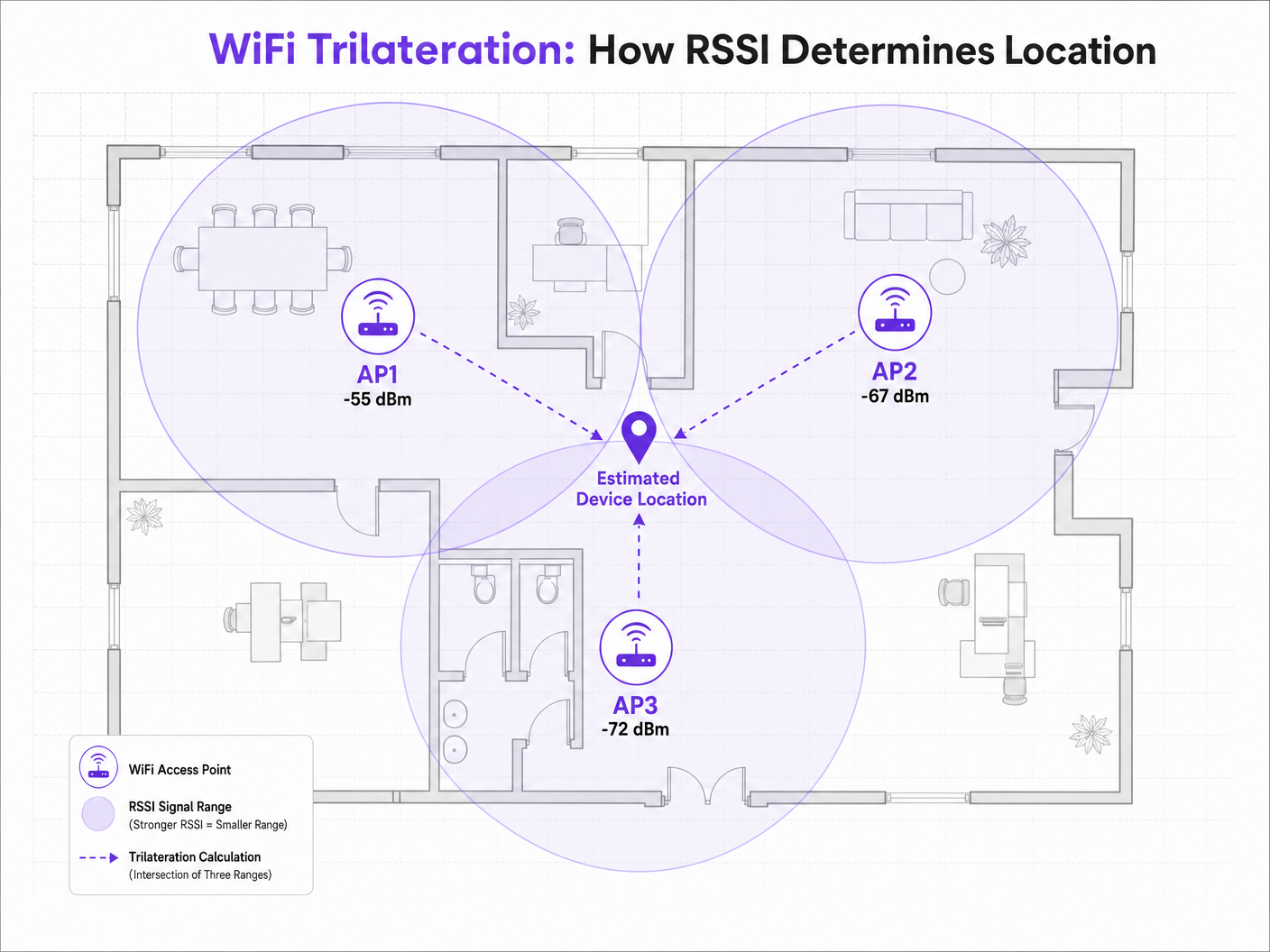
Lorsqu'un appareil client — tel qu'un smartphone diffusant des requêtes de sondage — est détecté par un AP, l'AP enregistre le RSSI. Étant donné que les signaux de radiofréquence (RF) s'atténuent (perdent de la puissance) lorsqu'ils traversent l'espace, la valeur RSSI sert de proxy pour la distance. Si trois AP ou plus détectent le même appareil et enregistrent son RSSI, le moteur de positionnement peut calculer la distance estimée de chaque AP, traçant des cercles de probabilité virtuels. L'intersection de ces cercles représente l'emplacement estimé de l'appareil.
Le Modèle d'Atténuation du Chemin
La relation entre le RSSI et la distance n'est pas linéaire ; elle suit un modèle d'atténuation du chemin logarithmique. La formule standard utilisée par les moteurs de positionnement est :
RSSI = -10 * n * log10(d) + A
Où :
- d est la distance par rapport au point d'accès.
- n est l'exposant d'atténuation du chemin, représentant la vitesse à laquelle le signal se dégrade dans l'environnement spécifique. Dans un vide spatial, n est exactement 2,0. Dans les environnements intérieurs denses, n peut varier de 3,0 à 4,5.
- A est le RSSI de référence mesuré à exactement 1 mètre de l'AP.
Cette formule souligne pourquoi la calibration environnementale est cruciale. Un déploiement dans un environnement Hôtellerie avec des murs en béton aura un exposant d'atténuation du chemin significativement différent de celui d'un espace Commerce de détail largement ouvert. Supposer une valeur n standard pour des environnements divers est la principale cause d'une faible précision de localisation.
2,4 GHz vs 5 GHz pour le Positionnement
Bien que la bande 2,4 GHz offre une meilleure pénétration à travers les obstacles physiques, cette caractéristique est en fait préjudiciable au positionnement de précision. L'empreinte de propagation plus large signifie des cercles d'estimation de distance plus grands, entraînant une zone d'intersection plus étendue et une résolution de positionnement plus faible.
La bande 5 GHz s'atténue plus rapidement, offrant des limites de signal plus strictes et des estimations de distance plus granulaires. Pour une précision de localisation optimale, les moteurs de positionnement devraient prioriser les données RSSI de 5 GHz. Ce principe s'applique également aux normes plus récentes ; bien que le Wi-Fi 6 améliore l'efficacité globale du réseau, les mécanismes fondamentaux du positionnement RSSI restent les mêmes, bien que l'introduction de la bande 6 GHz dans le Wi-Fi 6E offre une densité de canaux encore plus grande et des avantages potentiels en matière de résolution. Pour en savoir plus, consultez notre guide : Wi-Fi 6 vs Wi-Fi 5: Does it Solve Channel Interference? .
Guide d'Implémentation
Densité et Placement des Points d'Accès
Le mode de défaillance le plus courant dans les déploiements de localisation est une densité d'AP insuffisante. Un réseau conçu purement pour la connectivité (par exemple, pour fournir un accès WiFi Invité ) manque souvent de la densité requise pour une trilatération fiable.
Pour un positionnement fiable, un appareil client doit être « entendu » par un minimum de trois AP simultanément à un RSSI de -75 dBm ou mieux.
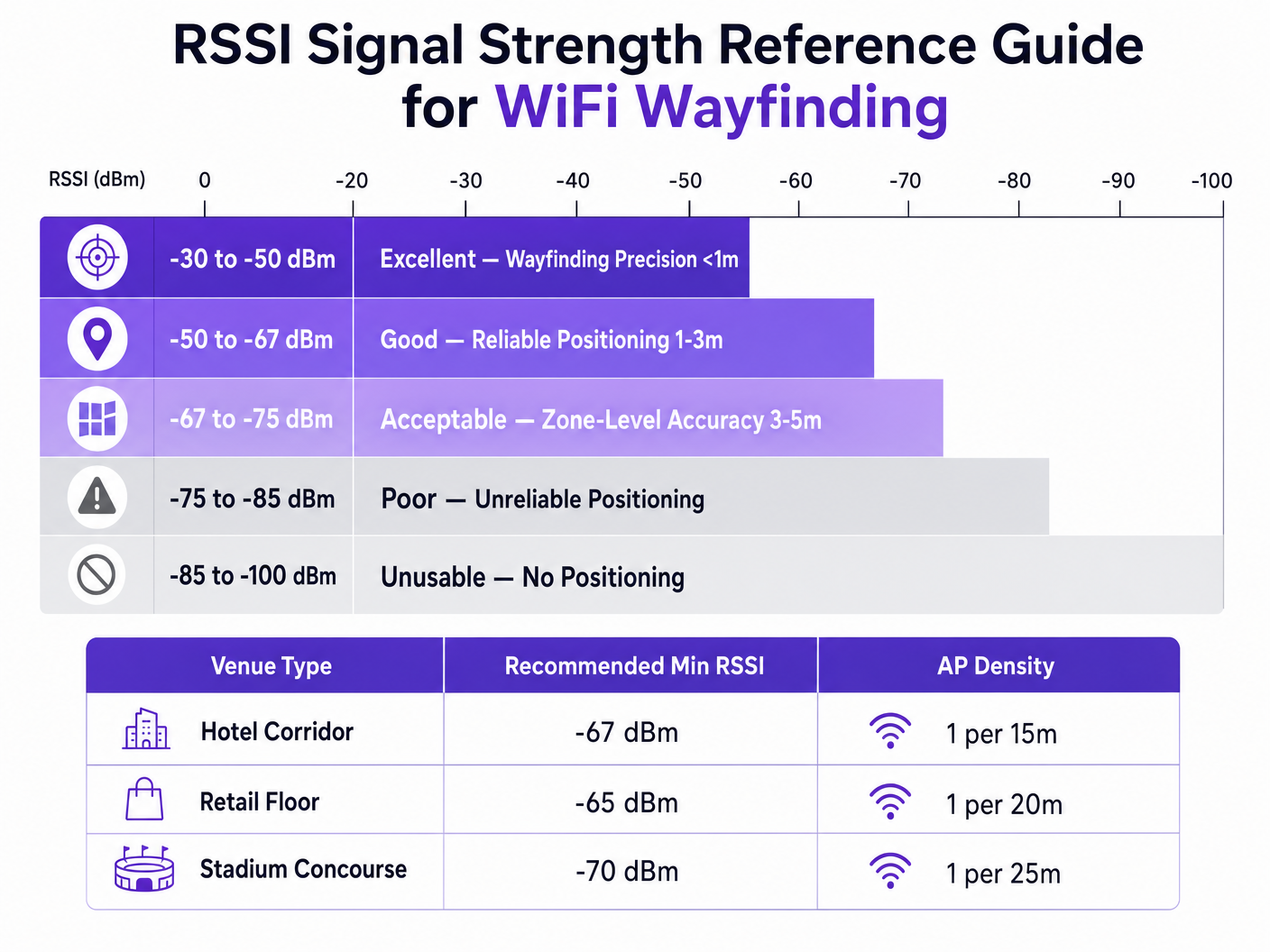
Pour atteindre une précision cible de 3 à 5 mètres, une règle générale est de déployer un AP pour 15 à 20 mètres carrés, selon l'environnement. De plus, les AP doivent être placés sur le périmètre de la zone cible, et non pas seulement au centre d'un couloir, pour garantir que l'intersection des cercles de signal crée un point définitif plutôt qu'une ligne droite.
Méthodologies de Calibration
Distance préciseL'estimation de la localisation nécessite de calibrer le moteur de positionnement à l'environnement RF spécifique. Il existe deux approches principales :
- RF Fingerprinting : Cela implique de parcourir physiquement le site avec un appareil de relevé, d'enregistrer les valeurs RSSI à des coordonnées connues et de construire une table de correspondance complète. Le moteur de positionnement compare ensuite les lectures RSSI en temps réel à cette base de données. Cette méthode offre la plus grande précision mais est très gourmande en main-d'œuvre et doit être répétée si l'environnement physique change (par exemple, les présentoirs de vente au détail saisonniers).
- Positionnement basé sur un modèle : Cette approche utilise la formule de perte de trajet combinée à des paramètres environnementaux (types de murs, hauteurs de plafond) définis dans le système. Elle est plus rapide à déployer et à maintenir, et bien que légèrement moins précise que le fingerprinting, elle est généralement suffisante pour l'analyse au niveau des zones et l'orientation générale.
Bonnes pratiques
Atténuation des interférences multi-trajets
Dans les environnements avec des surfaces très réfléchissantes – telles que les vitrines en verre, les installations métalliques ou les sièges de stade – les signaux RF rebondissent, arrivant au récepteur par plusieurs chemins. Cette interférence multi-trajets fausse la lecture RSSI, car le récepteur mesure un agrégat des signaux directs et réfléchis, plutôt que la distance en ligne de mire propre.
L'atténuation des multi-trajets nécessite une combinaison de placement stratégique des points d'accès (évitant les coins très réfléchissants), d'une calibration rigoureuse et d'algorithmes de filtrage intelligents au sein du moteur de positionnement capables d'écarter les pics RSSI anormaux.
Confidentialité et conformité
Lors de la collecte de données de localisation via les adresses MAC (même passivement par le biais de requêtes de sondage), les équipes informatiques doivent assurer la conformité avec les cadres de confidentialité régionaux comme le GDPR.
L'implémentation de la randomisation des adresses MAC par les systèmes d'exploitation mobiles modernes empêche le suivi à long terme des appareils individuels sans authentification. Cependant, elle n'entrave pas l'analyse agrégée de la fréquentation. Pour fournir une orientation individuelle pas à pas ou un engagement personnalisé, les sites doivent obtenir un consentement explicite.
C'est là que l'intégration d'un Captive Portal devient essentielle. En exigeant des utilisateurs qu'ils s'authentifient – peut-être en tirant parti d'une solution comme How a wi fi assistant Enables Passwordless Access in 2026 – les sites peuvent légalement associer un appareil à un individu et fournir des services de localisation avec consentement. La plateforme de Purple agit comme un fournisseur d'identité gratuit sous la licence Connect, simplifiant cette exigence de conformité tout en offrant de riches WiFi Analytics .
Dépannage et atténuation des risques
Lorsque la précision de l'orientation se dégrade, les équipes informatiques doivent évaluer systématiquement les vecteurs suivants :
- Dérive environnementale : Des changements physiques sont-ils survenus sur le site (nouveaux murs, inventaire dense) qui invalident la calibration originale ?
- Niveaux de puissance des points d'accès : Les algorithmes de gestion des ressources radio (RRM) ajustent-ils dynamiquement la puissance de transmission ? Les moteurs de positionnement s'appuient sur des points de référence stables ; des ajustements dynamiques agressifs de la puissance fausseront les calculs de distance.
- Variance des appareils clients : Différents fabricants de smartphones utilisent des conceptions d'antennes variées, ce qui signifie qu'un Samsung et un iPhone au même endroit peuvent signaler des valeurs RSSI différentes. Les moteurs de localisation avancés utilisent le profilage des appareils pour normaliser ces lectures.
ROI et impact commercial
L'analyse de rentabilité pour le déploiement d'une orientation WiFi robuste va bien au-delà de la simple affichage d'un point bleu sur une carte. Pour un directeur de la technologie (CTO) ou un directeur de site, le ROI est réalisé grâce à l'efficacité opérationnelle et à la prise de décision basée sur les données.
Dans un pôle de Transport , un positionnement précis permet une gestion dynamique des files d'attente et une affectation du personnel basée sur la densité de passagers en temps réel. Dans un environnement de soins de santé, il facilite le suivi des actifs pour les équipements médicaux de grande valeur, réduisant ainsi le gaspillage des achats.
En standardisant sur une plateforme agnostique au matériel comme Purple, les organisations peuvent extraire cette intelligence de localisation sans être liées à un seul fournisseur d'infrastructure, assurant une flexibilité à long terme et maximisant le retour sur leurs investissements sans fil existants. Comme souligné dans notre récente annonce, Purple Appoints Iain Fox as VP Growth – Public Sector to Drive Digital Inclusion and Smart City Innovation , l'application de cette technologie s'étend rapidement aux infrastructures de villes intelligentes, démontrant sa valeur évolutive.
Définitions clés
RSSI (Received Signal Strength Indicator)
A measurement of the power present in a received radio signal, expressed in decibels relative to a milliwatt (dBm).
The fundamental metric used by positioning engines to estimate the distance between a client device and an access point.
Trilateration
The process of determining absolute or relative locations of points by measurement of distances, using the geometry of circles, spheres or triangles.
The mathematical algorithm used by location engines to calculate a device's position based on distance estimates from multiple APs.
Path-Loss Exponent (n)
A variable in the RF propagation model that represents the rate at which signal strength degrades over distance in a specific environment.
Critical for calibration; an open stadium will have a lower path-loss exponent than a dense office environment with concrete walls.
RF Fingerprinting
A calibration technique where a venue is physically surveyed to record actual RSSI values at specific coordinates, creating a lookup database.
Used when high-precision wayfinding is required, though it carries a high operational maintenance cost.
Multipath Interference
A phenomenon in radio physics where RF signals reach the receiving antenna by two or more paths due to reflection off surfaces.
A major source of inaccuracy in wayfinding, particularly in venues with glass, metal, or complex architectural features.
MAC Address Randomisation
A privacy feature in modern mobile OS where the device broadcasts a temporary, randomized MAC address during probe requests.
Impacts the ability to track individual devices over time without network authentication, requiring venues to adapt their analytics strategies.
Probe Request
A frame sent by a client device to determine which access points are within range.
The primary mechanism for passive location tracking, allowing APs to record the RSSI of devices even if they are not connected to the network.
Model-Based Positioning
A location calculation method that relies on mathematical algorithms and environmental assumptions rather than physical site surveys.
The preferred deployment model for scalable, multi-site analytics where zone-level accuracy is sufficient.
Exemples concrets
A 400-room resort hotel is experiencing highly inaccurate wayfinding in its guest corridors, with the 'blue dot' frequently jumping between adjacent floors. The network was originally designed for basic connectivity with APs placed every 30 metres in a straight line down the centre of the hallways.
The IT team must redesign the RF architecture for location services. First, increase AP density to approximately one every 15 metres to ensure a minimum of three APs can 'hear' a client device at -67 dBm or better. Second, stagger the AP placement (e.g., alternating sides of the corridor or utilizing adjacent rooms) rather than a straight line. A straight-line deployment causes the trilateration circles to intersect at two distinct points, creating ambiguity. Finally, implement RF fingerprinting calibration specifically in the corridors to account for the high path-loss exponent caused by fire doors and concrete walls.
A large retail chain wants to deploy zone-level analytics to measure dwell time in specific departments (e.g., Electronics vs. Apparel) using their existing Cisco infrastructure. They want to avoid the operational overhead of manual RF fingerprinting across 50 locations.
Deploy a model-based positioning engine integrated with the existing Cisco wireless LAN controllers via API. The network architect should define the specific environmental parameters (path-loss exponent 'n') for the typical retail floor layout. Ensure that the WLCs are configured to report RSSI data from both associated and unassociated clients (probe requests). Overlay the Purple analytics platform to consume this API feed, mapping the logical AP coordinates to the physical floor plan to establish the analytical zones.
Questions d'entraînement
Q1. You are designing the WiFi infrastructure for a new conference centre. The primary requirement is highly accurate turn-by-turn wayfinding for attendees. The architect proposes placing high-density APs exclusively in the centre of the main exhibition halls to minimize cabling costs. Do you approve this design?
Conseil : Consider how trilateration circles intersect when APs are placed in a centralized cluster versus a perimeter deployment.
Voir la réponse type
No, this design should be rejected. For accurate trilateration, APs must be placed on the perimeter of the space to provide diverse angles of signal intersection. Centralized AP placement will result in overlapping signal circles that fail to create a definitive intersection point, leading to high positional ambiguity at the edges of the hall.
Q2. Following a recent firmware update to your wireless LAN controllers, the operations team reports that the dwell time analytics in the retail stores have become erratic, with devices appearing to 'teleport' between zones. No physical changes have been made to the stores.
Conseil : Consider what automated features a WLC firmware update might enable or alter regarding RF management.
Voir la réponse type
Investigate the Radio Resource Management (RRM) or dynamic transmit power control settings on the WLC. Firmware updates often alter the aggressiveness of these algorithms. If the APs are rapidly fluctuating their transmit power to optimize connectivity, the location engine's distance calculations (which rely on a stable reference power) will be entirely skewed, causing the 'teleporting' effect. RRM should be tuned to ensure stable transmit power in location-critical zones.
Q3. A hospital IT director wants to track the location of expensive mobile ultrasound machines. They currently have a legacy WiFi network designed for basic coverage (-75 dBm minimum). They are debating between upgrading the WiFi network for high-density location services or deploying a parallel BLE (Bluetooth Low Energy) beacon network.
Conseil : Evaluate the cost and accuracy trade-offs between upgrading a legacy WiFi network versus overlaying a targeted BLE solution for asset tracking.
Voir la réponse type
For precise asset tracking (e.g., knowing exactly which room a machine is in), BLE is often the more cost-effective and accurate solution in this scenario. Upgrading a legacy WiFi network to the density required for high-precision wayfinding (1 AP per 15 sqm) requires significant cabling and hardware investment. Deploying battery-powered BLE beacons on the assets and BLE receivers in the rooms provides higher accuracy (due to shorter range and lower power) without disrupting the existing WiFi infrastructure.