Die Mechanik der WiFi-Wegfindung: Trilateration und RSSI erklärt
Dieser maßgebliche Leitfaden erläutert die technischen Mechanismen der WiFi-Wegfindung und erklärt, wie Trilateration und RSSI-Messungen den Gerätestandort bestimmen. Er bietet umsetzbare Bereitstellungsstrategien, Kalibrierungsmethoden und Best Practices für die Architektur für IT-Führungskräfte, die Ortungsdienste in Unternehmensstandorten implementieren.
Diesen Leitfaden anhören
Podcast-Transkript ansehen

Executive Summary
Für Betreiber von Unternehmensstandorten erfordert die Bereitstellung effektiver Indoor-Ortungsdienste mehr als nur die Abdeckung eines Bereichs mit Access Points. Die grundlegende Mechanik der WiFi-Wegfindung – Trilateration und Received Signal Strength Indicator (RSSI)-Messungen – bestimmt die architektonischen Anforderungen für jede erfolgreiche Implementierung. Dieser Leitfaden bietet einen tiefen Einblick in die technischen Prinzipien, wie Ihre bestehende drahtlose Infrastruktur die Geräteposition bestimmt, die kritischen Umweltschwankungen, die die Genauigkeit beeinflussen, und die Bereitstellungsstandards, die erforderlich sind, um zuverlässige Standortinformationen zu liefern.
Das Verständnis dieser Mechanismen ist für IT-Manager und Netzwerkarchitekten, die mit der Bereitstellung von Turn-by-Turn-Navigation, Asset-Tracking oder Besucherfrequenzanalysen beauftragt sind, unerlässlich. Wir untersuchen die logarithmische Beziehung zwischen Signalstärke und Entfernung, die Notwendigkeit einer strengen Kalibrierung und die Integration hardwareunabhängiger Analyseplattformen wie Purple, um aus Ihrer RF-Umgebung einen umsetzbaren Geschäftswert zu ziehen.
Hören Sie sich unser begleitendes Podcast-Briefing an:
Technical Deep-Dive
The Fundamentals of RSSI and Trilateration
Im Kern basiert die WiFi-Wegfindung auf der bestehenden drahtlosen Infrastruktur, um den physischen Standort eines Client-Geräts zu bestimmen. Der primäre Mechanismus hierfür ist die Trilateration, die häufig und fälschlicherweise als Triangulation bezeichnet wird. Während die Triangulation die Position basierend auf Winkeln berechnet, bestimmt die Trilateration die Position durch Messung von Entfernungen von bekannten Referenzpunkten.
Im WiFi-Kontext sind diese Referenzpunkte Ihre Access Points (APs). Die Entfernungsschätzung wird vom Received Signal Strength Indicator (RSSI) abgeleitet. RSSI ist eine Messung der Leistung eines empfangenen Funksignals, ausgedrückt in Dezibel relativ zu einem Milliwatt (dBm).
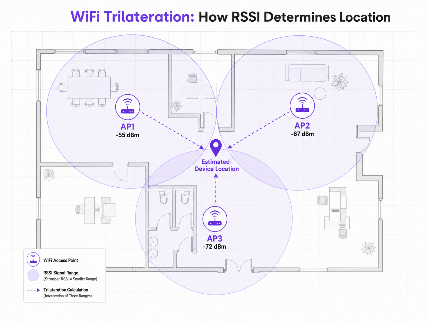
Wenn ein Client-Gerät – wie ein Smartphone, das Probe Requests sendet – von einem AP erkannt wird, zeichnet der AP den RSSI auf. Da Hochfrequenzsignale (RF) beim Durchqueren des Raumes gedämpft werden (Leistung verlieren), dient der RSSI-Wert als Stellvertreter für die Entfernung. Wenn drei oder mehr APs dasselbe Gerät erkennen und dessen RSSI aufzeichnen, kann die Positionierungs-Engine die geschätzte Entfernung von jedem AP berechnen und virtuelle Wahrscheinlichkeitskreise zeichnen. Der Schnittpunkt dieser Kreise stellt den geschätzten Gerätestandort dar.
The Path-Loss Model
Die Beziehung zwischen RSSI und Entfernung ist nicht linear; sie folgt einem logarithmischen Pfadverlustmodell. Die von Positionierungs-Engines verwendete Standardformel lautet:
RSSI = -10 * n * log10(d) + A
Wobei:
- d die Entfernung vom Access Point ist.
- n der Pfadverlustexponent ist, der darstellt, wie schnell das Signal in der spezifischen Umgebung abnimmt. In einem Vakuum im freien Raum ist n genau 2,0. In dichten Innenräumen kann n zwischen 3,0 und 4,5 liegen.
- A der Referenz-RSSI ist, gemessen in genau 1 Meter Entfernung vom AP.
Diese Formel verdeutlicht, warum die Umweltkalibrierung entscheidend ist. Eine Implementierung in einer Hospitality -Umgebung mit Betonwänden hat einen deutlich anderen Pfadverlustexponenten als eine weitläufige Retail -Fläche. Die Annahme eines Standard- n-Wertes über verschiedene Umgebungen hinweg ist die Hauptursache für eine schlechte Genauigkeit der Wegfindung.
2.4 GHz vs 5 GHz for Positioning
Während das 2.4 GHz-Band eine bessere Durchdringung physischer Hindernisse bietet, ist diese Eigenschaft für die präzise Positionierung tatsächlich nachteilig. Der größere Ausbreitungsbereich bedeutet größere Kreise für die Entfernungsschätzung, was zu einem größeren Schnittbereich und einer geringeren Positionsauflösung führt.
Das 5 GHz-Band dämpft schneller, was engere Signalbegrenzungen und granularere Entfernungsschätzungen ermöglicht. Für eine optimale Genauigkeit der Wegfindung sollten Positionierungs-Engines 5 GHz RSSI-Daten priorisieren. Dieses Prinzip gilt auch für neuere Standards; während Wi-Fi 6 die gesamte Netzwerkeffizienz verbessert, bleiben die grundlegenden Mechanismen der RSSI-Positionierung gleich, obwohl die Einführung des 6 GHz-Bandes in Wi-Fi 6E eine noch größere Kanaldichte und potenzielle Auflösungsvorteile bietet. Weitere Informationen hierzu finden Sie in unserem Leitfaden: Wi-Fi 6 vs Wi-Fi 5: Does it Solve Channel Interference? .
Implementation Guide
Access Point Density and Placement
Der häufigste Fehler bei der Implementierung von Wegfindungssystemen ist eine unzureichende AP-Dichte. Ein Netzwerk, das rein auf Konnektivität ausgelegt ist (z. B. zur Bereitstellung von Guest WiFi -Zugang), weist oft nicht die Dichte auf, die für eine zuverlässige Trilateration erforderlich ist.
Für eine zuverlässige Positionierung muss ein Client-Gerät gleichzeitig von mindestens drei APs mit einem RSSI von -75 dBm oder besser „gehört“ werden.
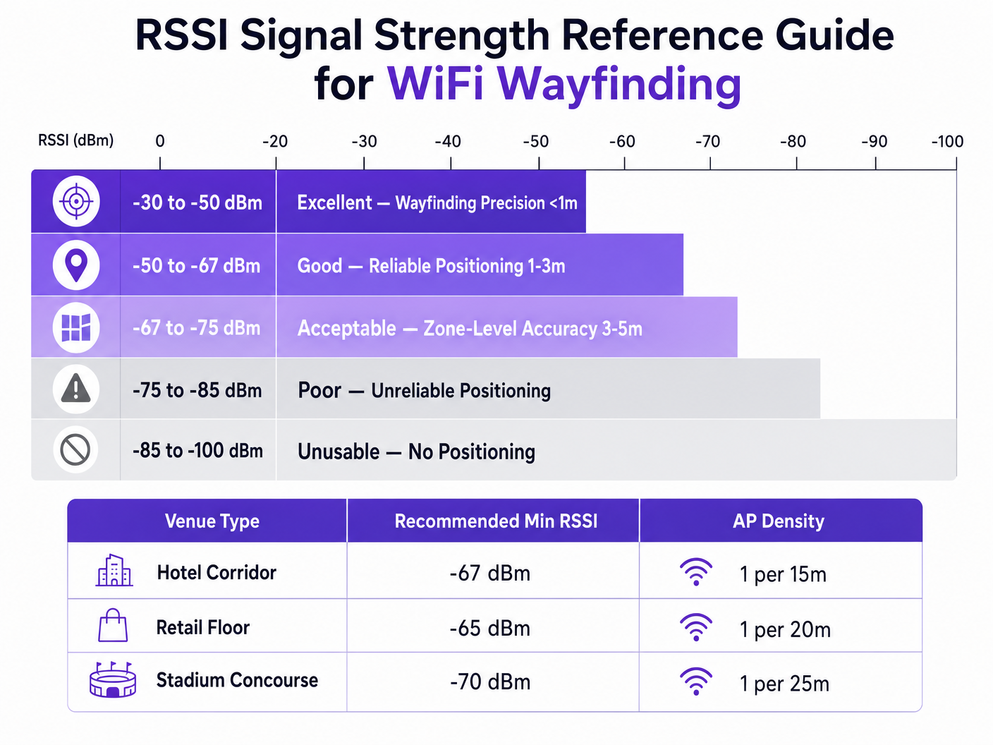
Um eine Zielgenauigkeit von 3 bis 5 Metern zu erreichen, gilt als Faustregel die Bereitstellung eines APs pro 15 bis 20 Quadratmeter, je nach Umgebung. Darüber hinaus sollten APs am Rand des Zielbereichs platziert werden, nicht nur in der Mitte eines Korridors, um sicherzustellen, dass der Schnittpunkt der Signalkreise einen eindeutigen Punkt und keine gerade Linie bildet.
Calibration Methodologies
Genaues EntfernDie Positionsschätzung erfordert die Kalibrierung der Positionierungs-Engine auf die spezifische RF-Umgebung. Es gibt zwei primäre Ansätze:
- RF Fingerprinting: Hierbei wird der Veranstaltungsort physisch mit einem Vermessungsgerät begangen, RSSI-Werte an bekannten Koordinaten aufgezeichnet und eine umfassende Nachschlagetabelle erstellt. Die Positionierungs-Engine gleicht dann Echtzeit-RSSI-Messwerte mit dieser Datenbank ab. Dies bietet die höchste Genauigkeit, ist jedoch sehr arbeitsintensiv und muss wiederholt werden, wenn sich die physische Umgebung ändert (z. B. saisonale Einzelhandelsauslagen).
- Modellbasierte Positionierung: Dieser Ansatz verwendet die Pfadverlustformel in Kombination mit im System definierten Umgebungsparametern (Wandtypen, Deckenhöhen). Er ist schneller zu implementieren und zu warten, und obwohl er etwas weniger genau ist als das Fingerprinting, ist er im Allgemeinen ausreichend für Analysen auf Zonenebene und eine umfassende Wegfindung.
Best Practices
Reduzierung von Mehrwegeinterferenzen
In Umgebungen mit stark reflektierenden Oberflächen – wie Glasfassaden, Metallvorrichtungen oder Stadionsitzen – werden RF-Signale reflektiert und erreichen den Empfänger über mehrere Pfade. Diese Mehrwegeinterferenz verfälscht den RSSI-Wert, da der Empfänger eine Summe der direkten und reflektierten Signale misst, anstatt der sauberen Sichtlinienentfernung.
Die Reduzierung von Mehrwegeeffekten erfordert eine Kombination aus strategischer AP-Platzierung (Vermeidung stark reflektierender Ecken), rigoroser Kalibrierung und intelligenten Filteralgorithmen innerhalb der Positionierungs-Engine, die anomale RSSI-Spitzen verwerfen können.
Datenschutz und Compliance
Beim Sammeln von Standortdaten über MAC-Adressen (selbst passiv über Probe Requests) müssen IT-Teams die Einhaltung regionaler Datenschutzrahmen wie der GDPR gewährleisten.
Die Implementierung der MAC-Adressen-Randomisierung durch moderne mobile Betriebssysteme verhindert die langfristige Verfolgung einzelner Geräte ohne Authentifizierung. Sie behindert jedoch nicht die aggregierte Besucherfrequenzanalyse. Um eine individuelle Turn-by-Turn-Wegfindung oder personalisiertes Engagement zu ermöglichen, müssen Veranstaltungsorte eine explizite Zustimmung einholen.
Hier wird die Integration eines Captive Portal unerlässlich. Indem Benutzer zur Authentifizierung aufgefordert werden – vielleicht unter Nutzung einer Lösung wie How a wi fi assistant Enables Passwordless Access in 2026 – können Veranstaltungsorte ein Gerät legal mit einer Person verknüpfen und Opt-in-Standortdienste anbieten. Die Plattform von Purple fungiert als kostenloser Identitätsanbieter unter der Connect-Lizenz, was diese Compliance-Anforderung rationalisiert und gleichzeitig umfassende WiFi Analytics liefert.
Fehlerbehebung & Risikominderung
Wenn die Genauigkeit der Wegfindung nachlässt, sollten IT-Teams systematisch die folgenden Faktoren bewerten:
- Umgebungsdrift: Haben sich physische Änderungen am Veranstaltungsort (neue Wände, dichtes Inventar) ereignet, die die ursprüngliche Kalibrierung ungültig machen?
- AP-Sendeleistungen: Passen Radio Resource Management (RRM)-Algorithmen die Sendeleistung dynamisch an? Positionierungs-Engines verlassen sich auf stabile Referenzpunkte; aggressive dynamische Leistungsanpassungen verfälschen Entfernungsberechnungen.
- Client-Gerätevarianz: Verschiedene Smartphone-Hersteller verwenden unterschiedliche Antennendesigns, was bedeutet, dass ein Samsung und ein iPhone am exakt gleichen Standort unterschiedliche RSSI-Werte melden können. Fortschrittliche Standort-Engines verwenden Geräteprofiling, um diese Messwerte zu normalisieren.
ROI & Geschäftsauswirkungen
Der Business Case für die Implementierung einer robusten WiFi-Wegfindung geht weit über die bloße Anzeige eines blauen Punktes auf einer Karte hinaus. Für einen Chief Technology Officer oder Venue Director wird der ROI durch operative Effizienz und datengesteuerte Entscheidungsfindung realisiert.
In einem Transport -Hub ermöglicht eine genaue Positionierung ein dynamisches Warteschlangenmanagement und die Personaldisposition basierend auf der Passagierdichte in Echtzeit. Im Gesundheitswesen erleichtert sie die Bestandsverfolgung von hochwertigen medizinischen Geräten und reduziert so den Beschaffungsabfall.
Durch die Standardisierung auf einer hardwareunabhängigen Plattform wie Purple können Organisationen diese Standortinformationen extrahieren, ohne an einen einzigen Infrastrukturanbieter gebunden zu sein, was langfristige Flexibilität gewährleistet und den Return on Investment ihrer bestehenden drahtlosen Investitionen maximiert. Wie in unserer jüngsten Ankündigung hervorgehoben, Purple Appoints Iain Fox as VP Growth – Public Sector to Drive Digital Inclusion and Smart City Innovation , expandiert die Anwendung dieser Technologie schnell in die Smart City-Infrastruktur und demonstriert ihren skalierbaren Wert.
Schlüsseldefinitionen
RSSI (Received Signal Strength Indicator)
A measurement of the power present in a received radio signal, expressed in decibels relative to a milliwatt (dBm).
The fundamental metric used by positioning engines to estimate the distance between a client device and an access point.
Trilateration
The process of determining absolute or relative locations of points by measurement of distances, using the geometry of circles, spheres or triangles.
The mathematical algorithm used by location engines to calculate a device's position based on distance estimates from multiple APs.
Path-Loss Exponent (n)
A variable in the RF propagation model that represents the rate at which signal strength degrades over distance in a specific environment.
Critical for calibration; an open stadium will have a lower path-loss exponent than a dense office environment with concrete walls.
RF Fingerprinting
A calibration technique where a venue is physically surveyed to record actual RSSI values at specific coordinates, creating a lookup database.
Used when high-precision wayfinding is required, though it carries a high operational maintenance cost.
Multipath Interference
A phenomenon in radio physics where RF signals reach the receiving antenna by two or more paths due to reflection off surfaces.
A major source of inaccuracy in wayfinding, particularly in venues with glass, metal, or complex architectural features.
MAC Address Randomisation
A privacy feature in modern mobile OS where the device broadcasts a temporary, randomized MAC address during probe requests.
Impacts the ability to track individual devices over time without network authentication, requiring venues to adapt their analytics strategies.
Probe Request
A frame sent by a client device to determine which access points are within range.
The primary mechanism for passive location tracking, allowing APs to record the RSSI of devices even if they are not connected to the network.
Model-Based Positioning
A location calculation method that relies on mathematical algorithms and environmental assumptions rather than physical site surveys.
The preferred deployment model for scalable, multi-site analytics where zone-level accuracy is sufficient.
Ausgearbeitete Beispiele
A 400-room resort hotel is experiencing highly inaccurate wayfinding in its guest corridors, with the 'blue dot' frequently jumping between adjacent floors. The network was originally designed for basic connectivity with APs placed every 30 metres in a straight line down the centre of the hallways.
The IT team must redesign the RF architecture for location services. First, increase AP density to approximately one every 15 metres to ensure a minimum of three APs can 'hear' a client device at -67 dBm or better. Second, stagger the AP placement (e.g., alternating sides of the corridor or utilizing adjacent rooms) rather than a straight line. A straight-line deployment causes the trilateration circles to intersect at two distinct points, creating ambiguity. Finally, implement RF fingerprinting calibration specifically in the corridors to account for the high path-loss exponent caused by fire doors and concrete walls.
A large retail chain wants to deploy zone-level analytics to measure dwell time in specific departments (e.g., Electronics vs. Apparel) using their existing Cisco infrastructure. They want to avoid the operational overhead of manual RF fingerprinting across 50 locations.
Deploy a model-based positioning engine integrated with the existing Cisco wireless LAN controllers via API. The network architect should define the specific environmental parameters (path-loss exponent 'n') for the typical retail floor layout. Ensure that the WLCs are configured to report RSSI data from both associated and unassociated clients (probe requests). Overlay the Purple analytics platform to consume this API feed, mapping the logical AP coordinates to the physical floor plan to establish the analytical zones.
Übungsfragen
Q1. You are designing the WiFi infrastructure for a new conference centre. The primary requirement is highly accurate turn-by-turn wayfinding for attendees. The architect proposes placing high-density APs exclusively in the centre of the main exhibition halls to minimize cabling costs. Do you approve this design?
Hinweis: Consider how trilateration circles intersect when APs are placed in a centralized cluster versus a perimeter deployment.
Musterlösung anzeigen
No, this design should be rejected. For accurate trilateration, APs must be placed on the perimeter of the space to provide diverse angles of signal intersection. Centralized AP placement will result in overlapping signal circles that fail to create a definitive intersection point, leading to high positional ambiguity at the edges of the hall.
Q2. Following a recent firmware update to your wireless LAN controllers, the operations team reports that the dwell time analytics in the retail stores have become erratic, with devices appearing to 'teleport' between zones. No physical changes have been made to the stores.
Hinweis: Consider what automated features a WLC firmware update might enable or alter regarding RF management.
Musterlösung anzeigen
Investigate the Radio Resource Management (RRM) or dynamic transmit power control settings on the WLC. Firmware updates often alter the aggressiveness of these algorithms. If the APs are rapidly fluctuating their transmit power to optimize connectivity, the location engine's distance calculations (which rely on a stable reference power) will be entirely skewed, causing the 'teleporting' effect. RRM should be tuned to ensure stable transmit power in location-critical zones.
Q3. A hospital IT director wants to track the location of expensive mobile ultrasound machines. They currently have a legacy WiFi network designed for basic coverage (-75 dBm minimum). They are debating between upgrading the WiFi network for high-density location services or deploying a parallel BLE (Bluetooth Low Energy) beacon network.
Hinweis: Evaluate the cost and accuracy trade-offs between upgrading a legacy WiFi network versus overlaying a targeted BLE solution for asset tracking.
Musterlösung anzeigen
For precise asset tracking (e.g., knowing exactly which room a machine is in), BLE is often the more cost-effective and accurate solution in this scenario. Upgrading a legacy WiFi network to the density required for high-precision wayfinding (1 AP per 15 sqm) requires significant cabling and hardware investment. Deploying battery-powered BLE beacons on the assets and BLE receivers in the rooms provides higher accuracy (due to shorter range and lower power) without disrupting the existing WiFi infrastructure.